SIGNIFICANCE OF ARCHAEOLOGICAL SITES FOR ESTIMATING COASTAL PLAIN DEVELOPMENT IN THE RENARDODDEN AREA, BELLSUND, SPITSBERGEN
|
|
|
- Bogdan Dobrowolski
- 6 lat temu
- Przeglądów:
Transkrypt

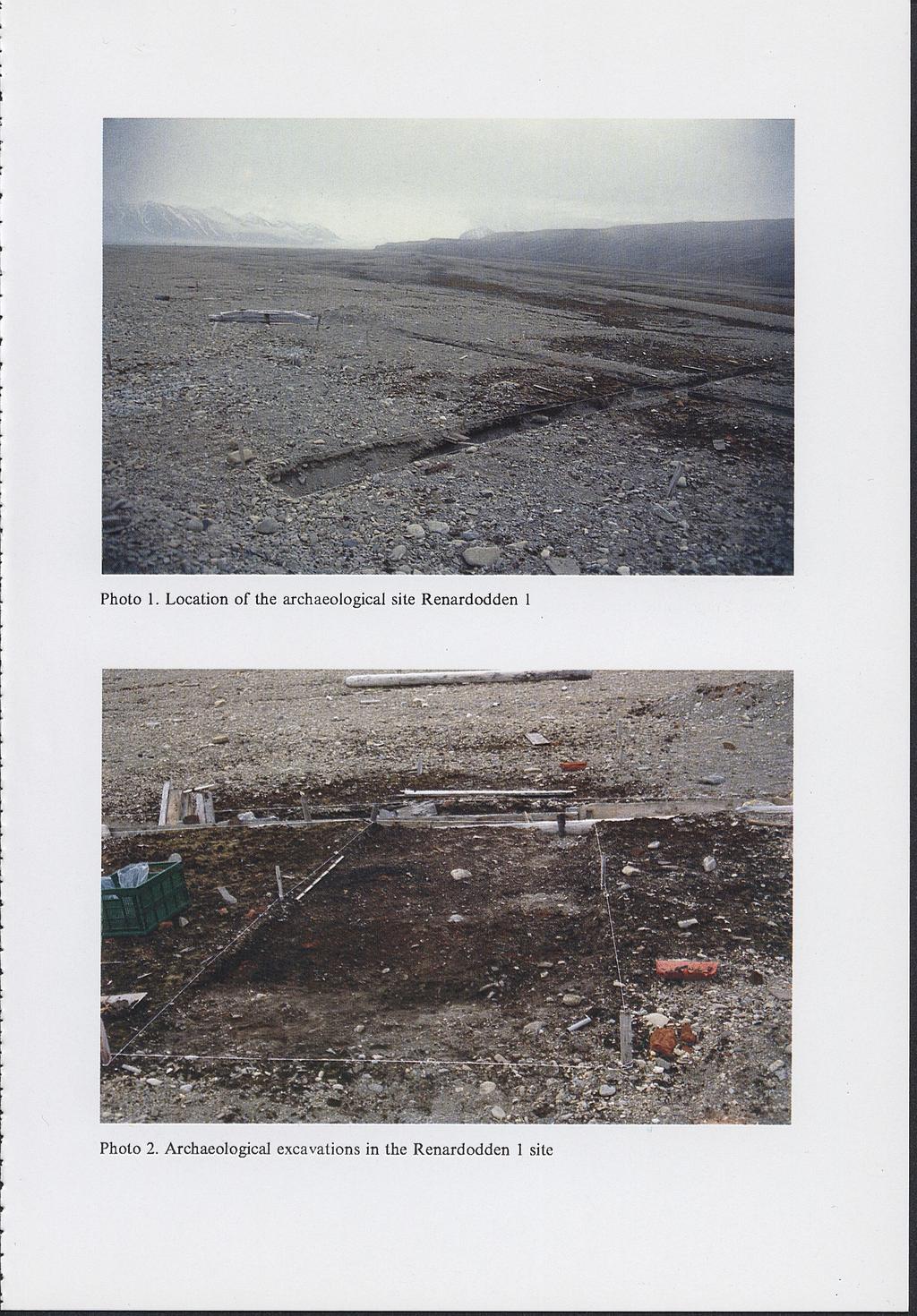
1 Marek E. JASIŃSKI University of Trondheim/Vilenskapsmuseet UMCS, Lublin, 1995 Department of Archaeology N-7004 Trondheim, NORWAY Piotr ZAGÓRSKI Department of Geomorphology Institute of Earth Sciences, Maria Curie-Skłodowska University Akademicka Lublin, POLAND Wyprawy Geograficzne na Spitsbergen SIGNIFICANCE OF ARCHAEOLOGICAL SITES FOR ESTIMATING COASTAL PLAIN DEVELOPMENT IN THE RENARDODDEN AREA, BELLSUND, SPITSBERGEN INTRODUCTION Joint archaeological/geomorphological research in Svalbard seems to offer opportunities for a better understanding of the cultural and natural processes taking place in the archipelago. This is the main reason for annual field cooperation between Norwegian and Russian archaeologists and Polish geomorphologists in the Bellsund and Recherche Fjord area of Spitsbergen. In 1995, preliminary archaeological/geomorphological studies were carried out in the Renardodden area on the south coast of Bellsund by staff from the Department of Geomorphology at the Maria Curie-Skłodowska University and the Department of Archaeology at the University of Trondheim. Archaeological investigations of sites there (Jasiński et al. 1993, Jasiński & Zavyalov 1995) have provided data on erosion and accumulation in historical times. In turn, studies of such processes have provided data for evaluating the development of cultural layers on archaeological sites. MORPHOLOGICAL FEATURES AND GEODYNAMIC CONDITIONS OF COASTAL DEVELOPMENT IN THE RENARDODDEN AREA Renardodden is situated at the mouth of Recherche Fjord in the northwest part od Wedel Jarlsberg Land. It is an accumulative marine terrace 1-6 m a.s.l. (Harasimiuk & Jezierski, 1988) composed of material derived from the cliff in Skilvika and the delta of the River Scott which enters Recherche Fjord 35
 and Palaeogene shales, mudstones and sandstones with coal fragments (Krasilshchikov &")
2 approximately 600 m southwest of Renardodden (Fig. 1, Photo 1). The material consists mainly of gravels of Proterozoic and Palaeozoic metamorphic rocks (Hecla Hoek Formation) and Palaeogene shales, mudstones and sandstones with coal fragments (Krasilshchikov & Kovaleva, 1979; Dallmann et al., 1990; Hjelle, 1993). The marine terrace is formed of a system of storm ridges and a broad beach of sandy-gravelly sediments. In the southwest, it is bordered by a inactive cliff of a 35 m terrace, which is being affected by solifluction. This cliff consists of Pleistocene gravels and boulder clays overlying mudstones, sands and marine gravels (Troitsky et al., 1979, Landvik et al., 1987, Pękala & Repelewska-Pękalowa, 1990) deposited on an erosion platform of Tertiary sandstones (Dallmann et al., 1990). Strong erosive and accumulative processes caused by waves, tides and coastal currents are observed in the Renardodden area. Deposition of fluvioglacial material forms a temporary delta in the estuary of the River Scott. The current passing along the northwest coast and powerful waves remove this material, carrying it along the shore in a northerly direction (Harasimiuk & Król, 1992). Another current moving east from Skilvika erodes the Renardodden beach in the north and adds to it in the east. Thus, the cape is influenced by two coastal currents heavily loaded with terrigenous material. However, a major force causing transport and, above all, deposition of material on the shore, is strong waves, particularly during autumn storms. These promote intensive marine accumulation, illustrated by the rapid growth of the beach and the creation or destruction of storm ridges. These processes can be estimated from the terrace configuration as well as by the position and state of preservation of archaeological sites (Jasiński et al., 1993). ARCHAEOLOGICAL SITES The three archaeological sites so far recognised in the Renardodden area, belong to two phases of Svalbard history: west European whaling in the 17th century and Russian hunting (Jasiński, 1993). R e n a r d o d d e n 1 stands on the promontory itself (Jasiński et al., 1993: 75-77; Fig. 1, 2, 3, За, 4). Preliminary excavations in 1995 (Jasiński & Zavyalov, 1995) confirmed earlier assumptions about the Russian origin of this site (Krawczyk & Reder, 1989; Jasiński et al., 1993: 75-77). It marks the remains of a station belonging to walrus hunters from the Pomorye area (the White Sea coast). The artifacts found indicate a relatively late date - probably the first half of the 19th century (Jasiński & Zavyalov, 1995) (Photo 2). R e n a r d o d d e n 2 is located 97 m south of Renardodden 1 (Jasiński et al., 1993: 77-78; Figs. 2, 5, 5a, 5b) and consists of eight structures which are probably the remains of a west European whaling station from the 17th century. 36

3 R e n a r d o d d e n 3 stands 213 m south of Renardodden 2 (Jasiński et al., 1993:78-80; Figs. 2,6,6a, 8). It comprises the sites of five tents (?) and seven open fireplaces. The tent sites are only represented by characteristic mounds of pebbles with rows of stones on the top. Artifacts found on the surface suggest that the site represents a west European whaling station from the 17th century. CHARACTERISTICS OF THE COASTAL ZONE BASED ON GEOMORPHOLOG1CAL STUDIES AND ARCHAEOLOGICAL DATA To determine the changes in the coastal zone in this area a profile (5.15 m long and 0.7 m deep) was made as an extension of archaeological trial trench В excavated in 1995 at Renardodden 1 (Jasiński & Zavyalov, 1995), (Fig. 2). It was found that 5 m from the centre of the site, the occupation layer was covered by gravelly-sandy material at a depth of 0.25 m. The occupation layer, which had already been largely destroyed, continued to decrease under the gravel (Photo 3). Alternating layers of gravel and sand overlying the occupation layer illustrate the action of strong waves in the period after the buildings were demolished - probably in the first half of the 19th century. The site is now just within the reach of storm waves (Fig. ЗА). An 18 m wide snow bank (zone A), also called the inner beach (Jezierski, 1992), is beyond the reach of waves in summer. Zone В is an area covered by gravelly-sandy material that increases in thickness towards the sea. This zone also contains characteristic gravel mounds formed in response to the melting of ice buried by material that accumulates during storms. An area of discontinuous gravelly-sandy material (zone C), 42 m from the high tide level, is also distinguished. To provide better data on marine erosion and accumulation, a topographical profile was drawn about 100 m southeast of Renardodden 1 (Fig. 3B). Two distinct, old storm ridges were found here which are morphologically marked in the direction of the River Scott. The Renardodden 1 site stands on storm ridge III. The other two sites from the whaling period are on storm ridges IV (Renardodden 3) and V (Renardodden 2), respectively. During autumn storms, considerable quantities of gravel and sand are thrown across the inner beach (or snow bank) to accumulate on the slope of storm ridge II, more than 30 m from the high tide level. The inner beach is marked by deep depressions (up to 5 m wide and 1.5 m deep) filled with gravelly-sandy material and is separated from the sea by the present storm ridge (Photo 4). 37
. Its low position above sea level and the close proximity of the sea have resulted in partial destruction of the site by the sea.")
4 STAGES OF COASTAL DEVELOPMENT AND THEIR INFLUENCE ON THE RENARDODDEN 1 SITE Renardodden 1 belongs to a group of sites with quite atypical topographical location, recorded by archaeologists on Spitsbergen (Chochorowski & Jasiński, 1993). Its low position above sea level and the close proximity of the sea have resulted in partial destruction of the site by the sea. Why should Russian walrus hunters choose such a location for their station? Geomorphological studies and archaeological excavations reveal several stages of coastal development at Renardodden. Probably at the end of the 18th or the beginning of the 19th century, a Russian hunting station was built on the storm ridge which was then beyond the reach of the sea. Probably around the middle of the 19th century, the coast began to be increasingly eroded. The remains of the station came within the reach of waves, as shown by the reduction of the occupation layęr beneath younger marine sediments. The old storm ridge was damaged by storm waves and pieces of brick and organic relicts were spread over the inner beach zone. After this period of erosion, a new storm ridge formed in a relatively short time through the increased supply of material to the shore. The archaeological site then began to be buried, the storm ridge gradually grew and the shore zone extended. The present renewed destruction of the storm ridge may be due to the recession of the Scott Glacier and the reduced supply of material to the shore zone. These preliminary results of geomorphological research on an archaeological site in Svalbard show the potential of such joint work in the archipelago. They can help to solve at least some of the serious problems which the two disciplines have to deal with in this part of the Arctic. Archaeological investigations give geomorphologists better dating information. Geomorphological results, in turn, help to explain some of the features archaeologists try to explain. REFERENCES Chochorowski J., Jasiński M. E., 1993: Topography, structure and chronology of Russian hunting stations on the west coast of Spitsbergen. In: Jasiński, Marek E., Pomors in Grumant. Archaeological studies of Russian hunting stations in Svalbard. Vol. II, Part 3, 33 pp. Universitetet i Tromso. Dallmann W. K., Hjelle A., Ohta Y., Salvigsen O., Bjornerud M. G., Hauser E. C., Mäher H. D., Craddock C., 1990: Geological Map of Svalbard 1:100,000 Sheet BUG Van Keulenfjorden, Norsk Polarinstitutt, Oslo. Harasimiuk M., Jezierski W., 1988: Typy wybrzeża Południowego Bellsundu. Wyprawy Geograficzne na Spitsbergen, UMCS Lublin, Harasimiuk M., Król Т., 1992: The dynamie of morphogenetic and sedimentary processes in the estuary segments of river valleys in the Recherche Fiord (Western Spitsbergen). Wyprawy Geograficzne na Spitsbergen, UMCS Lublin,

5 Hjelle A., 1993: Geology of Svalbard. Norsk PolarinstituU, Oslo, 162 pp. Jasiński M. E., 1993: Pomors in Grumant. Archaeological studies of Russian hunting stations in Svalbard. Universitetet i Tromso. Jasiński M. E., Starkov V. F., Zavyalov V. I., Zimin E. N., 1993: Archaeological sites at cape Renard, Bellsund, Spitsbergen. XX Polar Symposium, Lublin, Jasiński M. E., Zavyalov V. I., 1995: Archaeological excavations of a Russian hunting station at the Renardodden 1 site, Recherche Fjord, Spitsbergen. Field Work Wyprawy Geograficzne na Spitsbergen, UMCS Lublin. Jezierski W., 1992: Spatial changeability of dynamics of marine sediment processes in Calypsostranda Region (Recherche Fiord, Western Spitsbergen). Wyprawy Geograficzne na Spitsbergen, UMCS Lublin, Krasilshchikov A. A., Kovaleva G. A., 1979: Precambrian rock-stratigraphic units of the west coast of Spitsbergen. Norsk PolarinstituU, Oslo. Landvik J. Y., Mangerud J., Salvigsen O., 1987: The Late Weichselian and Holocene shoreline displacement on the west-central coast of Svalbard. Polar Research, Pękala К., Repelewska-Pękalowa J., 1990: Relief and stratigraphy of Quaternary deposits in the region of Recherche Fiord and Southern Bellsund (Western Spitsbergen). Wyprawy Geograficzne na Spitsbergen, UMCS Lublin, Troitsky L., Punning J. M., Hütt G., Rajamäe R., 1979: Pleistocene glaciation chronology of Spitsbergen. Boreas, vol. 4, STRESZCZENIE Podczas X Ekspedycji na Spitsbergen UMCS, zorganizowanej w 1995 roku, zostały przeprowadzone wstępne badania archeologiczne i geomorfologiczne w strefie przylądka Renardodden na południowym wybrzeżu Bellsundu. Występują tam stanowiska archeologiczne, które pozwoliły na ocenę rozwoju procesów abrazji i akumulacji w czasach historycznych. W rejonie Renardodden zachodzą obecnie bardzo intensywne procesy abrazji i akumulacji. Sprzyjają temu takie zjawiska jak: falowanie, pływy morskie oraz prądy przybrzeżne. Jednym z głównych czynników powodujących przemieszczanie, a przede wszystkim wyrzucanie materiału na brzeg jest silne falowanie, szczególnie w okresie jesiennych sztormów. Sprzyja to intensywnym procesom akumulacji morskiej co uwidacznia się w szybkim narastaniu plaży i tworzeniu nowych młodych wałów burzowych lub abrazyjnym ich niszczeniu. Oceny tych procesów można dokonać na podstawie ukształtowania terasy oraz rozmieszczenia i stanu zachowania stanowisk archeologicznych. W świetle przeprowadzonych badań geomorfologicznych i opierając się na danych archeologicznych można wyróżnić kilka etapów kształtowania wybrzeża w rejonie Renardodden. Najprawdopodobniej na początku XIX wieku został wybudowany budynek rosyjskiej stacji łowieckiej na wale burzowym, który znajdował siępoza zasięgiem ówczesnej działalności morskiej. Prawdopodobnie połowa XIX wieku to okresy narastania procesów abrazji, które doprowadziły do ścinania wybrzeża. Stary wał burzowy został zniszczony przez fale sztormowe, zaś okruchy cegieł i szczątki organiczne rozwleczone są w strefie falezy. Po okresie abrazji doszło do szybkiego tworzenia nowego wału burzowego, związanego ze zwiększoną dostawą materiału do strefy brzegowej. Nastąpiło wówczas przysypywanie stanowiska archeologicznego oraz stopniowe narastanie wału burzowego i rozszerzanie strefy brzegowej. Procesy te należy wiązać z większą aktywnością niszczenia klifu w Skilvice oraz wzmożoną dostawą materiału przez rzekę Scotta z przedpola lodowca Scotta i jego awansem. Współczesny etap niszczenia wałów burzowych może mieć związek z recesją lodowca Scotta i zmniejszoną dostawą materiału do strefy brzegowej morza. 39
![0 100 200 300 [m] 1 i i i Fig. 1. Location and geomorphological map of the Renardodden 1 site: 1 - marine terrace 35-45 m a.s.l., 2 - marine terrace 18-30 m a.s.l., 3 - terrace 16-18 m a.s.l., 4 - marine terrace 1-6 m a.](/docs-images/93/113951338/images/6-0.jpg "s.l., 5 - contemporary beach, 6 - extramarginal outwash of the River Scott, 7 - alluvial cone, 8 - slope of inactive and active cliffs, 9 - directions of coastal currents, 10 - erosion edges, 11 -")
6 [m] 1 i i i Fig. 1. Location and geomorphological map of the Renardodden 1 site: 1 - marine terrace m a.s.l., 2 - marine terrace m a.s.l., 3 - terrace m a.s.l., 4 - marine terrace 1-6 m a.s.l., 5 - contemporary beach, 6 - extramarginal outwash of the River Scott, 7 - alluvial cone, 8 - slope of inactive and active cliffs, 9 - directions of coastal currents, 10 - erosion edges, 11 - storm ridges, 12 - location of Renardodden 1 and lines of sections 40
![[m a.s.l.] 3.0 5.0 5.5 6.0 6.5 7.0 7.5 8.0 8.5 9.0 [m] i i i i i i i i i 1 Fig. 2.](/docs-images/93/113951338/images/7-0.jpg "Geological profile across part of the storm ridge near the Renardodden 1 site: 1 - occupation layer, 2 - sand, 3 - sand and gravel, 4 - gravel 0 10 20 30 40 50 60 70 80 90 [m] 1 1 1 1 1 1 i i i i Fig.")
7 [m a.s.l.] [m] i i i i i i i i i 1 Fig. 2. Geological profile across part of the storm ridge near the Renardodden 1 site: 1 - occupation layer, 2 - sand, 3 - sand and gravel, 4 - gravel [m] i i i i Fig. 3. Topographical profiles across the storm ridges near the Renardodden 1 site: 1 - gravelly-sandy sediments from the autumn and winter of , H - high tide level, M - mean tide level, L-low tide level. A - Snow bank (inner beach) zone, В - Zone of gravelly-sandy material with gravel mounds, С - Zone of discontinuous gravelly-sandy material 41
8

9 Photo 4. Depression in the snow bank zone
THE SVARTHAMEREN ARCHAEOLOGICAL SITE COMPLEX AT ROBERT RIVER, RECHERCHEFJORDEN - SPITSBERGEN
 Marek Е. JASIŃSKI History and Archaeology Museum of Natural University of Trondheim 7004 Trondheim, NORWAY Kazimierz PĘKALA Department of Geomorphology Institute of Earth Sciences Maria Curie-Skłodowska
INSTYTUT NAUK O ZIEMI UNIWERSYTETU MARII CURIE-SKŁODOWSKIEJ KOMISJA ZMARZLINOZNAWSTWA KOMITETU BADAŃ POLARNYCH POLSKIEJ AKADEMII NAUK SESJA POLARNA
 INSTYTUT NAUK O ZIEMI UNIWERSYTETU MARII CURIE-SKŁODOWSKIEJ KOMISJA ZMARZLINOZNAWSTWA KOMITETU BADAŃ POLARNYCH POLSKIEJ AKADEMII NAUK SESJA POLARNA PROBLEMY ŚRODOWISKA NATURALNEGO ARKTYKI Lublin, czerwiec
Recession and development of marginal zone of the Scott Glacier
 Point 5 Push moraine of the Scott Glacier 77 33 36" N, 14 26 11" E Recession and development of marginal zone of the Scott Glacier Jan Reder, Piotr Zagórski * Department of Geomorphology, Institute of
TEMPERATURA GRUNTU W CALYPSOBYEN (ZACHODNI SPITSBERGEN) W SEZONIE LETNIM 1994 ROKU
 W SEZONIE LETNIM 1994 ROKU") Anna BI LIK Department of Meteorology and Climatology Institute of Earth Sciences Maria Curie-Skłodowska University Akademicka 19 20-033 Lublin, POLAND Wyprawy Geograficzne па Spitsbergen IV Zjazd Geomorfologów
Anna BI LIK Department of Meteorology and Climatology Institute of Earth Sciences Maria Curie-Skłodowska University Akademicka 19 20-033 Lublin, POLAND Wyprawy Geograficzne па Spitsbergen IV Zjazd Geomorfologów
Recession and development of marginal zone of the Renard Glacier
 Point 2/Point 2A Forefield of the Renard Glacier 2 77 32 37" N, 14 32 41" E 2A 77 32 23" N, 14 29 47" E Recession and development of marginal zone of the Renard Glacier Jan Reder, Piotr Zagórski * Department
Sprawozdanie z badań nad dynamiką strefy brzegowej południowego Bellsundu (III Wyprawa UMCS na Spitsbergen 1988 r.)
") Waldemar Jezierski Instytut Nauk o Ziemi Uniwersytet Marii Curie-Skłodowskiej w Lublinie Wyprawy Geograficzne UMCS w Lublinie na Spitsbergen 1986-1988 Sesja Polarna 1989 Sprawozdanie z badań nad dynamiką
Waldemar Jezierski Instytut Nauk o Ziemi Uniwersytet Marii Curie-Skłodowskiej w Lublinie Wyprawy Geograficzne UMCS w Lublinie na Spitsbergen 1986-1988 Sesja Polarna 1989 Sprawozdanie z badań nad dynamiką
WEATHER CONDITIONS IN CALYPSOBYEN IN THE SUMMER 1993 (WEST SPITSBERGEN)
") Pawei CZUBLA Institute of Earth Sciences Maria Curie-Skłodowska University Akademicka 19 20-033 Lublin, P O L A N D W>prawy Geograficzne na Spitsbergen UMCS, Lublin, 1994 WEATHER CONDITIONS IN CALYPSOBYEN
Pawei CZUBLA Institute of Earth Sciences Maria Curie-Skłodowska University Akademicka 19 20-033 Lublin, P O L A N D W>prawy Geograficzne na Spitsbergen UMCS, Lublin, 1994 WEATHER CONDITIONS IN CALYPSOBYEN
ICE CONDITIONS IN NOTTINGHAMBUKTA DURING SEASONS
 Barbara WISNIEWSKA Chair of Genetic University of Gdańsk Kładki 24, 80-882 Gdańsk POLAND POLISH POLAR STUDIES X X V I Polar S y m p o s i u m ЭШжУ Lublin, June 1999 ICE CONDITIONS IN NOTTINGHAMBUKTA DURING
dynamics of permafrost active layer were carried out in the eight summer periods in the Recherche Fiord border (the Bellsund southern region).
.") Janina REPELEWSKA-PĘKALOWA Department of Geomorphology Institute of Earth Sciences Maria Curie-Skłodowska University Akademicka 19 20-033 Lublin, P O L A N D Wyprawy Geograficzne na Spitsbergen UMCS. Lublin,
Janina REPELEWSKA-PĘKALOWA Department of Geomorphology Institute of Earth Sciences Maria Curie-Skłodowska University Akademicka 19 20-033 Lublin, P O L A N D Wyprawy Geograficzne na Spitsbergen UMCS. Lublin,
Sargent Opens Sonairte Farmers' Market
 Sargent Opens Sonairte Farmers' Market 31 March, 2008 1V8VIZSV7EVKIRX8(1MRMWXIVSJ7XEXIEXXLI(ITEVXQIRXSJ%KVMGYPXYVI *MWLIVMIWERH*SSHTIVJSVQIHXLISJJMGMEPSTIRMRKSJXLI7SREMVXI*EVQIVW 1EVOIXMR0E]XS[R'S1IEXL
Fizyka Procesów Klimatycznych Wykład 11 Aktualne zmiany klimatu: atmosfera, hydrosfera, kriosfera
 Fizyka Procesów Klimatycznych Wykład 11 Aktualne zmiany klimatu: atmosfera, hydrosfera, kriosfera prof. dr hab. Szymon Malinowski Instytut Geofizyki, Wydział Fizyki Uniwersytet Warszawski malina@igf.fuw.edu.pl
5.5. Coastal geomorphology
 Piotr Zagórski, Jan Rodzik and Mateusz C. Strzelecki Piotr Zagórski Jan Rodzik Mateusz Czesław Strzelecki 5.5. Coastal geomorphology The recently published The State of Arctic Coast 2010 Report (Forbes
STANOWISKA ARCHEOLOGICZNE NA PRZYLĄDKU RENARDA, SPITSBERGEN
 Y. F. STARKOV Institute of Archaeology Russian Academy of Sciences Ulianov 19 11703036 Moscow, RUSSIA Wyprawy Geograficzne па Spitsbergen IV Zjazd Geomorfologów Polskich UMCS, Lublin 3-6 czerwca 1998 A
ARCHAEOLOGICAL SITES IN NORTH-WEST WEDEL JARLSBERG LAND
 Vadim F. STARKOV Institute of Archaeology Russian Academy of Sciences Ulianov 19 11703036 Moscow, RUSSIA Marek E.JASIŃSKI Department of Archaeology University of Trondheim/Vitenskapsmuseet N-7004 Trondheim,
SPIS TREŚCI CONTENTS
 > SPIS TREŚCI CONTENTS Słowo wstępne 7 A. F. Gluza, J. Piasecki Rola cyrkulacji atmosferycznej w kształtowaniu cech klimatu południowego Bellsundu na przykładzie sezonu wiosenno-letniego 1987 r 9 The importance
 www.irs.gov/form990. If "Yes," complete Schedule A Schedule B, Schedule of Contributors If "Yes," complete Schedule C, Part I If "Yes," complete Schedule C, Part II If "Yes," complete Schedule C, Part
SSW1.1, HFW Fry #20, Zeno #25 Benchmark: Qtr.1. Fry #65, Zeno #67. like
 SSW1.1, HFW Fry #20, Zeno #25 Benchmark: Qtr.1 I SSW1.1, HFW Fry #65, Zeno #67 Benchmark: Qtr.1 like SSW1.2, HFW Fry #47, Zeno #59 Benchmark: Qtr.1 do SSW1.2, HFW Fry #5, Zeno #4 Benchmark: Qtr.1 to SSW1.2,
Dzierżek J., Nitychoruk J., 1987: Stożki usypiskowe okolic Bellsundu, Spitsbergen Zachodni. XIV Sympozjum Polarne, Lublin,
 BIBLIOGRAPHY GEOLOGY AND GEOMORPHOLOGY Bartoszewski S., Repelewska-Pękalowa J., 1988: Chemical and mechanical denudation in the selected river basins of the southern margin of Bellsund (W Spitsbergen).
SOLIFLUCTION PROCESSES IN RECHERCHEFJORDEN (WESTERN SPITSBERGEN)
") Janina Repelewska-Pękalowa Kazimierz Pękala Institute of Earth Sciences Maria Curie-Sklodowska University Lublin, Poland Wyprawy Geograficzne na Spitsbergen UMCS, Lublin 1992 SOLIFLUCTION PROCESSES IN
Janina Repelewska-Pękalowa Kazimierz Pękala Institute of Earth Sciences Maria Curie-Sklodowska University Lublin, Poland Wyprawy Geograficzne na Spitsbergen UMCS, Lublin 1992 SOLIFLUCTION PROCESSES IN
 www.irs.gov/form990. If "Yes," complete Schedule A Schedule B, Schedule of Contributors If "Yes," complete Schedule C, Part I If "Yes," complete Schedule C, Part II If "Yes," complete Schedule C, Part
STAN I ZMIANY ŚRODOWISKA PRZYRODNICZEGO
 1 UNIWERSYTET MARII CURIE-SKŁODOWSKIEJ Instytut Nauk o Ziemi w Lublinie Polskie Towarzystwo Geograficzne Oddział Lubelski Klub Polarny PTG STAN I ZMIANY ŚRODOWISKA PRZYRODNICZEGO PÓŁNOCNO-ZACHODNIEJ CZĘŚCI
NEOTECTONIC MOVEMENTS RECORD IN THE SPIT DEPOSITS OF THE WESTERN AND CENTRAL POLISH COAST IN THE LIGHT OF GEOLOGICAL AND SEISMIC INVESTIGATIONS
 NEOTECTONIC MOVEMENTS RECORD IN THE SPIT DEPOSITS OF THE WESTERN AND CENTRAL POLISH COAST IN THE LIGHT OF GEOLOGICAL AND SEISMIC INVESTIGATIONS Ryszard Dobracki Polish Geological Institute Pomeranian Branch
European Crime Prevention Award (ECPA) Annex I - new version 2014
 Annex I - new version 2014") European Crime Prevention Award (ECPA) Annex I - new version 2014 Załącznik nr 1 General information (Informacje ogólne) 1. Please specify your country. (Kraj pochodzenia:) 2. Is this your country s ECPA
European Crime Prevention Award (ECPA) Annex I - new version 2014 Załącznik nr 1 General information (Informacje ogólne) 1. Please specify your country. (Kraj pochodzenia:) 2. Is this your country s ECPA
Cracow University of Economics Poland. Overview. Sources of Real GDP per Capita Growth: Polish Regional-Macroeconomic Dimensions 2000-2005
 Cracow University of Economics Sources of Real GDP per Capita Growth: Polish Regional-Macroeconomic Dimensions 2000-2005 - Key Note Speech - Presented by: Dr. David Clowes The Growth Research Unit CE Europe
Słupskie Prace Geograficzne
 Słupskie Prace Geograficzne 4 2007 Piotr Zagórski Zakład Geomorfologii Instytut Nauk o Ziemi Uniwersytet Marii Curie-Skłodowskiej Lublin WPŁYW LODOWCÓW NA PRZEKSZTAŁCENIE WYBRZEśY NW CZĘŚCI ZIEMI WEDELA
DOI: / /32/37
 . 2015. 4 (32) 1:18 DOI: 10.17223/1998863 /32/37 -,,. - -. :,,,,., -, -.,.-.,.,.,. -., -,.,,., -, 70 80. (.,.,. ),, -,.,, -,, (1886 1980).,.,, (.,.,..), -, -,,,, ; -, - 346, -,.. :, -, -,,,,,.,,, -,,,
SPITSBERGEN HORNSUND
 Polska Stacja Polarna Instytut Geofizyki Polska Akademia Nauk Polish Polar Station Institute of Geophysics Polish Academy of Sciences BIULETYN METEOROLOGICZNY METEOROLOGICAL BULLETIN SPITSBERGEN HORNSUND
Wykaz linii kolejowych, które są wyposażone w urządzenia systemu ETCS
 Wykaz kolejowych, które są wyposażone w urządzenia W tablicy znajdującej się na kolejnych stronach tego załącznika zastosowano następujące oznaczenia: - numer kolejowej według instrukcji Wykaz Id-12 (D-29).
Extraclass. Football Men. Season 2009/10 - Autumn round
 Extraclass Football Men Season 2009/10 - Autumn round Invitation Dear All, On the date of 29th July starts the new season of Polish Extraclass. There will be live coverage form all the matches on Canal+
Ewolucja i współczesne wykształcenie wybrzeŝa NW części Ziemi Wedela Jarlsberga (Spitsbergen)
") XX lat badań polarnych Instytutu Nauk o Ziemi UMCS na Spitsbergenie Piotr ZAGÓRSKI Marian HARASIMIUK Waldemar JEZIERSKI Ewolucja i współczesne wykształcenie wybrzeŝa NW części Ziemi Wedela Jarlsberga (Spitsbergen)
XX lat badań polarnych Instytutu Nauk o Ziemi UMCS na Spitsbergenie Piotr ZAGÓRSKI Marian HARASIMIUK Waldemar JEZIERSKI Ewolucja i współczesne wykształcenie wybrzeŝa NW części Ziemi Wedela Jarlsberga (Spitsbergen)
Dominika Janik-Hornik (Uniwersytet Ekonomiczny w Katowicach) Kornelia Kamińska (ESN Akademia Górniczo-Hutnicza) Dorota Rytwińska (FRSE)
 Kornelia Kamińska (ESN Akademia Górniczo-Hutnicza) Dorota Rytwińska (FRSE)") Czy mobilność pracowników uczelni jest gwarancją poprawnej realizacji mobilności studentów? Jak polskie uczelnie wykorzystują mobilność pracowników w programie Erasmus+ do poprawiania stopnia umiędzynarodowienia
Czy mobilność pracowników uczelni jest gwarancją poprawnej realizacji mobilności studentów? Jak polskie uczelnie wykorzystują mobilność pracowników w programie Erasmus+ do poprawiania stopnia umiędzynarodowienia
Wykaz linii kolejowych, które są wyposażone w urzadzenia systemu ETCS
 Wykaz kolejowych, które są wyposażone w urzadzenia W tablicy znajdującej się na kolejnych stronach tego załącznika zastosowano następujące oznaczenia: - numer kolejowej według instrukcji Wykaz Id-12 (D-29).
Temiika tundry i dynamika czynnej warstwy zmarzliny na przedpolu lodowców Scotta i Renarda (rejon Bellsundu, Zachodni Spitsbergen)
") XIV Sympozjum Polarne, Lublin 198V Instytut Nauk o Ziemi Uniwersytetu Marii Curie-Skłodowskiej, Lublin J. REPELEWSKA-PĘKALOWA, A. F. GLUZA, K. DĄBROWSKI Temiika tundry i dynamika czynnej warstwy zmarzliny
XIV Sympozjum Polarne, Lublin 198V Instytut Nauk o Ziemi Uniwersytetu Marii Curie-Skłodowskiej, Lublin J. REPELEWSKA-PĘKALOWA, A. F. GLUZA, K. DĄBROWSKI Temiika tundry i dynamika czynnej warstwy zmarzliny
Katowice, plan miasta: Skala 1: = City map = Stadtplan (Polish Edition)
") Katowice, plan miasta: Skala 1:20 000 = City map = Stadtplan (Polish Edition) Polskie Przedsiebiorstwo Wydawnictw Kartograficznych im. Eugeniusza Romera Click here if your download doesn"t start automatically
Katowice, plan miasta: Skala 1:20 000 = City map = Stadtplan (Polish Edition) Polskie Przedsiebiorstwo Wydawnictw Kartograficznych im. Eugeniusza Romera Click here if your download doesn"t start automatically
yft Lublin, June 1999
 Waldemar STAROŃ Janusz MIELNIK Henryk GURGUL Department of Sea Physics Chair of Physics Szczecin University Wielkopolska 15,70-451 Szczecin POLAND POLISH POLAR STUDIES XXVI Polar Symposium yft Lublin,
SPITSBERGEN HORNSUND
 Polska Stacja Polarna Instytut Geofizyki Polska Akademia Nauk Polish Polar Station Institute of Geophysics Polish Academy of Sciences BIULETYN METEOROLOGICZNY METEOROLOGICAL BULLETIN SPITSBERGEN HORNSUND
(PL ) ŚWIAToWIT viii (XLIX)/A he first field season of the Polish-Turkmen excavations
 ŚWIAToWIT viii (XLIX)/A he first field season of the Polish-Turkmen excavations") ŚWIAToWIT viii (XLIX)/A 2009 2010 BArBArA KAIM ThE first SEASON Of ExCAvATiON AT GuRuKLY DEPE, SOuThERN TuRKMENiSTAN, 2010 (PL. 213 215) T he first field season of the Polish-Turkmen excavations at Gurukly
ŚWIAToWIT viii (XLIX)/A 2009 2010 BArBArA KAIM ThE first SEASON Of ExCAvATiON AT GuRuKLY DEPE, SOuThERN TuRKMENiSTAN, 2010 (PL. 213 215) T he first field season of the Polish-Turkmen excavations at Gurukly
KATOWICE SPECIAL ECONOMIC ZONE GLIWICE SUBZONE and its influence on local economy KATOWICE SPECIAL ECONOMIC ZONE - GLIWICE SUBZONE
 KATOWICE SPECIAL ECONOMIC ZONE GLIWICE SUBZONE and its influence on local economy Definition: WHAT DOES THE SPECIAL ECONOMIC ZONE MEAN? THE SPECIAL ECONOMIC ZONE IS THE SEPERATED AREA WITH ATTRACTIVE TAX
PORTS AS LOGISTICS CENTERS FOR CONSTRUCTION AND OPERATION OF THE OFFSHORE WIND FARMS - CASE OF SASSNITZ
 Part-financed by EU South Baltic Programme w w w. p t m e w. p l PROSPECTS OF THE OFFSHORE WIND ENERGY DEVELOPMENT IN POLAND - OFFSHORE WIND INDUSTRY IN THE COASTAL CITIES AND PORT AREAS PORTS AS LOGISTICS
River Drzewiczka, Poland
 River Drzewiczka, Poland Location The Drzewiczka basin is located in the centre of Poland. The river is a right side tributary of the Pilica river, which is a left side tributary of the river Wisła flowing
Krytyczne czynniki sukcesu w zarządzaniu projektami
 Seweryn SPAŁEK Krytyczne czynniki sukcesu w zarządzaniu projektami MONOGRAFIA Wydawnictwo Politechniki Śląskiej Gliwice 2004 SPIS TREŚCI WPROWADZENIE 5 1. ZARZĄDZANIE PROJEKTAMI W ORGANIZACJI 13 1.1. Zarządzanie
 aforementioned device she also has to estimate the time when the patients need the infusion to be replaced and/or disconnected. Meanwhile, however, she must cope with many other tasks. If the department
SPITSBERGEN HORNSUND
 Polska Stacja Polarna Instytut Geofizyki Polska Akademia Nauk Polish Polar Station Institute of Geophysics Polish Academy of Sciences BIULETYN METEOROLOGICZNY METEOROLOGICAL BULLETIN SPITSBERGEN HORNSUND
SPITSBERGEN HORNSUND
 Polska Stacja Polarna Instytut Geofizyki Polska Akademia Nauk Polish Polar Station Institute of Geophysics Polish Academy of Sciences BIULETYN METEOROLOGICZNY METEOROLOGICAL BULLETIN SPITSBERGEN HORNSUND
Machine Learning for Data Science (CS4786) Lecture11. Random Projections & Canonical Correlation Analysis
 Lecture11. Random Projections & Canonical Correlation Analysis") Machine Learning for Data Science (CS4786) Lecture11 5 Random Projections & Canonical Correlation Analysis The Tall, THE FAT AND THE UGLY n X d The Tall, THE FAT AND THE UGLY d X > n X d n = n d d The
Machine Learning for Data Science (CS4786) Lecture11 5 Random Projections & Canonical Correlation Analysis The Tall, THE FAT AND THE UGLY n X d The Tall, THE FAT AND THE UGLY d X > n X d n = n d d The
Zagłębienia po górach lodowych jako wskaźnik klimatostratygraficzny rozwoju teras morskich południowego Spitsbergenu*
 Leszek Lindner, Leszek Marks Instytut Geologii Podstawowej Uniwersytet Warszawski Wyprawy Geograficzne UMCS w Lublinie na Spitsbergen 1986-1988 Sesja Polarna 1989 Zagłębienia po górach lodowych jako wskaźnik
SPITSBERGEN HORNSUND
 Polska Stacja Polarna Instytut Geofizyki Polska Akademia Nauk Polish Polar Station Institute of Geophysics Polish Academy of Sciences BIULETYN METEOROLOGICZNY METEOROLOGICAL BULLETIN SPITSBERGEN HORNSUND
MULTI-MODEL PROJECTION OF TEMPERATURE EXTREMES IN POLAND IN
 MULTI-MODEL PROJECTION OF TEMPERATURE EXTREMES IN POLAND IN 2021-2050 Joanna Jędruszkiewicz Department of Meteorology and Climatology University of Lodz, Poland jjedruszkiewicz@gmail.com Funded by grant
Skala zjawisk abrazyjnych w minionym 20 leciu na przykładzie Mierzei Dziwnowskiej
 Skala zjawisk abrazyjnych w minionym 20 leciu na przykładzie Mierzei Dziwnowskiej Kazimierz Furmańczyk, Joanna Dudzińska-Nowak Uniwersytet Szczeciński, Instytut Nauk o Morzu Europejska Agencja Środowiska:
Has the heat wave frequency or intensity changed in Poland since 1950?
 Has the heat wave frequency or intensity changed in Poland since 1950? Joanna Wibig Department of Meteorology and Climatology, University of Lodz, Poland OUTLINE: Motivation Data Heat wave frequency measures
Tychy, plan miasta: Skala 1: (Polish Edition)
") Tychy, plan miasta: Skala 1:20 000 (Polish Edition) Poland) Przedsiebiorstwo Geodezyjno-Kartograficzne (Katowice Click here if your download doesn"t start automatically Tychy, plan miasta: Skala 1:20 000
Tychy, plan miasta: Skala 1:20 000 (Polish Edition) Poland) Przedsiebiorstwo Geodezyjno-Kartograficzne (Katowice Click here if your download doesn"t start automatically Tychy, plan miasta: Skala 1:20 000
Galeria Handlowa Starogard Gdański
 Galeria Handlowa Starogard Gdański Parkridge Retail Miasto Starogard Gdański leży w południowo-wschodniej części województwa pomorskiego, w pobliżu Borów Tucholskich, nad rzeką Wierzycą na Pojezierzu Starogardzkim.
Updated Action Plan received from the competent authority on 4 May 2017
 1 To ensure that the internal audits are subject to Response from the GVI: independent scrutiny as required by Article 4(6) of Regulation (EC) No 882/2004. We plan to have independent scrutiny of the Recommendation
The Overview of Civilian Applications of Airborne SAR Systems
 The Overview of Civilian Applications of Airborne SAR Systems Maciej Smolarczyk, Piotr Samczyński Andrzej Gadoś, Maj Mordzonek Research and Development Department of PIT S.A. PART I WHAT DOES SAR MEAN?
Joint fractures on the southern shore of Bellsund, Spitsbergen
 POLISH POLAR RESEARCH to 1 81 89 1989 Wojciech OZIMKOWSKI Institute of Geology Warsaw University Żwirki i Wigury 93 02-089 Warszawa, POLAND Joint fractures on the southern shore of Bellsund, Spitsbergen
Cracow University of Economics Poland
 Cracow University of Economics Poland Sources of Real GDP per Capita Growth: Polish Regional-Macroeconomic Dimensions 2000-2005 - Keynote Speech - Presented by: Dr. David Clowes The Growth Research Unit,
Instrukcja konfiguracji usługi Wirtualnej Sieci Prywatnej w systemie Mac OSX
 UNIWERSYTETU BIBLIOTEKA IEGO UNIWERSYTETU IEGO Instrukcja konfiguracji usługi Wirtualnej Sieci Prywatnej w systemie Mac OSX 1. Make a new connection Open the System Preferences by going to the Apple menu
SPITSBERGEN HORNSUND
 Polska Stacja Polarna Instytut Geofizyki Polska Akademia Nauk Polish Polar Station Institute of Geophysics Polish Academy of Sciences BIULETYN METEOROLOGICZNY METEOROLOGICAL BULLETIN SPITSBERGEN HORNSUND
ZGŁOSZENIE WSPÓLNEGO POLSKO -. PROJEKTU NA LATA: APPLICATION FOR A JOINT POLISH -... PROJECT FOR THE YEARS:.
 ZGŁOSZENIE WSPÓLNEGO POLSKO -. PROJEKTU NA LATA: APPLICATION FOR A JOINT POLISH -... PROJECT FOR THE YEARS:. W RAMACH POROZUMIENIA O WSPÓŁPRACY NAUKOWEJ MIĘDZY POLSKĄ AKADEMIĄ NAUK I... UNDER THE AGREEMENT
Wojewodztwo Koszalinskie: Obiekty i walory krajoznawcze (Inwentaryzacja krajoznawcza Polski) (Polish Edition)
 (Polish Edition)") Wojewodztwo Koszalinskie: Obiekty i walory krajoznawcze (Inwentaryzacja krajoznawcza Polski) (Polish Edition) Robert Respondowski Click here if your download doesn"t start automatically Wojewodztwo Koszalinskie:
Wojewodztwo Koszalinskie: Obiekty i walory krajoznawcze (Inwentaryzacja krajoznawcza Polski) (Polish Edition) Robert Respondowski Click here if your download doesn"t start automatically Wojewodztwo Koszalinskie:
METEOROLOGICAL CONDITIONS OF THE SCOTT RIVER OUTFLOW IN THE SUMMER 1990 (WESTERN SPITSBERGEN)
") Stefan Bartoszewski, Krzysztof Institute of Earth Sciences Maria Curie-Sklodowska University Lublin, Poland Siwek W>prawy Geograficzne na Spitsbergen UMCS, Lublin 1992 METEOROLOGICAL CONDITIONS OF THE
Stefan Bartoszewski, Krzysztof Institute of Earth Sciences Maria Curie-Sklodowska University Lublin, Poland Siwek W>prawy Geograficzne na Spitsbergen UMCS, Lublin 1992 METEOROLOGICAL CONDITIONS OF THE
Zagrożenie powodziowe na obszarach zurbanizowanych w dolnym biegu Odry
 The flood threat from severe high water events in the urban area of the lower Odra River Zagrożenie powodziowe na obszarach zurbanizowanych w dolnym biegu Odry Halina Kowalewska-Kalkowska Coastal Marine
Miedzy legenda a historia: Szlakiem piastowskim z Poznania do Gniezna (Biblioteka Kroniki Wielkopolski) (Polish Edition)
 (Polish Edition)") Miedzy legenda a historia: Szlakiem piastowskim z Poznania do Gniezna (Biblioteka Kroniki Wielkopolski) (Polish Edition) Piotr Maluskiewicz Click here if your download doesn"t start automatically Miedzy
Miedzy legenda a historia: Szlakiem piastowskim z Poznania do Gniezna (Biblioteka Kroniki Wielkopolski) (Polish Edition) Piotr Maluskiewicz Click here if your download doesn"t start automatically Miedzy
Rzeźba peryglacjalna rejonu Bellsundu (Spitsbergen) w aspekcie badań Wypraw Polarnych UMCS
 w aspekcie badań Wypraw Polarnych UMCS") XX lat badań polarnych Instytutu Nauk o Ziemi UMCS na Spitsbergenie Janina REPELEWSKA-PĘKALOWA Kazimierz PĘKALA Rzeźba peryglacjalna rejonu Bellsundu (Spitsbergen) w aspekcie badań Wypraw Polarnych UMCS
XX lat badań polarnych Instytutu Nauk o Ziemi UMCS na Spitsbergenie Janina REPELEWSKA-PĘKALOWA Kazimierz PĘKALA Rzeźba peryglacjalna rejonu Bellsundu (Spitsbergen) w aspekcie badań Wypraw Polarnych UMCS
EXAMPLES OF CABRI GEOMETRE II APPLICATION IN GEOMETRIC SCIENTIFIC RESEARCH
 Anna BŁACH Centre of Geometry and Engineering Graphics Silesian University of Technology in Gliwice EXAMPLES OF CABRI GEOMETRE II APPLICATION IN GEOMETRIC SCIENTIFIC RESEARCH Introduction Computer techniques
Karpacz, plan miasta 1:10 000: Panorama Karkonoszy, mapa szlakow turystycznych (Polish Edition)
") Karpacz, plan miasta 1:10 000: Panorama Karkonoszy, mapa szlakow turystycznych (Polish Edition) J Krupski Click here if your download doesn"t start automatically Karpacz, plan miasta 1:10 000: Panorama
Karpacz, plan miasta 1:10 000: Panorama Karkonoszy, mapa szlakow turystycznych (Polish Edition) J Krupski Click here if your download doesn"t start automatically Karpacz, plan miasta 1:10 000: Panorama
SPITSBERGEN HORNSUND
 Polska Stacja Polarna Instytut Geofizyki Polska Akademia Nauk Polish Polar Station Institute of Geophysics Polish Academy of Sciences BIULETYN METEOROLOGICZNY METEOROLOGICAL BULLETIN SPITSBERGEN HORNSUND
Helena Boguta, klasa 8W, rok szkolny 2018/2019
 Poniższy zbiór zadań został wykonany w ramach projektu Mazowiecki program stypendialny dla uczniów szczególnie uzdolnionych - najlepsza inwestycja w człowieka w roku szkolnym 2018/2019. Składają się na
Baptist Church Records
 Baptist Church Records The Baptist religion was a religious minority in Poland, making it more difficult to know when and where records of this religion might be available. In an article from Rodziny,
ERASMUS + : Trail of extinct and active volcanoes, earthquakes through Europe. SURVEY TO STUDENTS.
 ERASMUS + : Trail of extinct and active volcanoes, earthquakes through Europe. SURVEY TO STUDENTS. Strona 1 1. Please give one answer. I am: Students involved in project 69% 18 Student not involved in
PhD Łukasz Gawor Silesian University of Technology, Gliwice Akademicka Street 2, Gliwice, PL, phone , fax
 PhD Łukasz Gawor Silesian University of Technology, Gliwice Akademicka Street 2, 44-100 Gliwice, PL, phone +48 694 202 157, fax +48 32 237 22 90 Introduction In Polish coal industry the post-mining waste
 www.irs.gov/form990. If "Yes," complete Schedule A Schedule B, Schedule of Contributors If "Yes," complete Schedule C, Part I If "Yes," complete Schedule C, Part II If "Yes," complete Schedule C, Part
Badania polarne i peryglacjalne prof. dr hab. Kazimierza Pękali
 XX lat badań polarnych Instytutu Nauk o Ziemi UMCS na Spitsbergenie Józef SUPERSON Badania polarne i peryglacjalne prof. dr hab. Kazimierza Pękali Prof. dr hab. Kazimierz Pękala urodził się 28 sierpnia
Nazwa projektu: Kreatywni i innowacyjni uczniowie konkurencyjni na rynku pracy
 Nazwa projektu: Kreatywni i innowacyjni uczniowie konkurencyjni na rynku pracy DZIAŁANIE 3.2 EDUKACJA OGÓLNA PODDZIAŁANIE 3.2.1 JAKOŚĆ EDUKACJI OGÓLNEJ Projekt współfinansowany przez Unię Europejską w
ZRÓŻNICOWANIE ALBEDO CALYPSOSTRANDY (ZACHODNI SPITSBERGEN) W SEZONIE LETNIM
 W SEZONIE LETNIM") Problemy Klimatologii Polarnej 15 2005 113 117 ZRÓŻNICOWANIE ALBEDO CALYPSOSTRANDY (ZACHODNI SPITSBERGEN) W SEZONIE LETNIM 2001 1 THE ALBEDO DIFERENTIATION AT CALYPSOSTRANDA (W SPITSBERGEN) IN SUMMER SEASON
Problemy Klimatologii Polarnej 15 2005 113 117 ZRÓŻNICOWANIE ALBEDO CALYPSOSTRANDY (ZACHODNI SPITSBERGEN) W SEZONIE LETNIM 2001 1 THE ALBEDO DIFERENTIATION AT CALYPSOSTRANDA (W SPITSBERGEN) IN SUMMER SEASON
Badanie i prognozowanie zmian brzegu morza bezpływowego.
 Zakład Teledetekcji i Kartografii Morskiej Instytut Nauk o Morzu Wydział Nauk o Ziemi Uniwersytet Szczeciński Badanie i prognozowanie zmian brzegu morza bezpływowego. (w pracach Zakładu Teledetekcji i
 !850016! www.irs.gov/form8879eo. e-file www.irs.gov/form990. If "Yes," complete Schedule A Schedule B, Schedule of Contributors If "Yes," complete Schedule C, Part I If "Yes," complete Schedule C,
Zarządzanie sieciami telekomunikacyjnymi
 SNMP Protocol The Simple Network Management Protocol (SNMP) is an application layer protocol that facilitates the exchange of management information between network devices. It is part of the Transmission
Domy inaczej pomyślane A different type of housing CEZARY SANKOWSKI
 Domy inaczej pomyślane A different type of housing CEZARY SANKOWSKI O tym, dlaczego warto budować pasywnie, komu budownictwo pasywne się opłaca, a kto się go boi, z architektem, Cezarym Sankowskim, rozmawia
Network Services for Spatial Data in European Geo-Portals and their Compliance with ISO and OGC Standards
 INSPIRE Conference 2010 INSPIRE as a Framework for Cooperation Network Services for Spatial Data in European Geo-Portals and their Compliance with ISO and OGC Standards Elżbieta Bielecka Agnieszka Zwirowicz
Analysis of Movie Profitability STAT 469 IN CLASS ANALYSIS #2
 Analysis of Movie Profitability STAT 469 IN CLASS ANALYSIS #2 aaaklnictzzjb9tgfmcnadpg7oy0lxa9edva9kkapdarhyk2k7gourinlwsweyzikuyiigvyleiv/cv767fpf/5crc1xt9va5mx7w3m/ecuqw1kuztpx/rl3/70h73/w4cog9dhhn3z62d6jzy+yzj766txpoir9nzszisjynetqr+rvlfvyoozu5xbybpsxb1wahul8phczdt2v4zgchb7uecwphlyigrgkjcyiflfyci0kxnmr4z6kw0jsokvot8isntpa3gbknlcufiv/h+hh+eur4fomd417rvtfjoit5pfju6yxiab2fmwk0y/feuybobqk+axnke8xzjjhfyd8kkpl9zdoddkazd5j6bzpemjb64smjb6vb4xmehysu08lsrszopxftlzee130jcb0zjxy7r5wa2f1s2off2+dyatrughnrtpkuprlcpu55zlxpss/yqe2eamjkcf0jye8w8yas0paf6t0t2i9stmcua+inbi2rt01tz22tubbqwidypvgz6piynkpobirkxgu54ibzoti4pkw2i5ow9lnuaoabhuxfxqhvnrj6w15tb3furnbm+scyxobjhr5pmj5j/w5ix9wsa2tlwx9alpshlunzjgnrwvqbpwzjl9wes+ptyn+ypy/jgskavtl8j0hz1djdhzwtpjbbvpr1zj7jpg6ve7zxfngj75zee0vmp9qm2uvgu/9zdofq6r+g8l4xctvo+v+xdrfr8oxiwutycu0qgyf8icuyvp/sixfi9zxe11vp6mrjjovpmxm6acrtbia+wjr9bevlgjwlz5xd3rfna9g06qytaoofk8olxbxc7xby2evqjmmk6pjvvzxmpbnct6+036xp5vdbrnbdqph8brlfn/n/khnfumhf6z1v7h/80yieukkd5j0un82t9mynxzmk0s/bzn4tacdziszdhwrl8x5ako8qp1n1zn0k6w2em0km9zj1i4yt1pt3xiprw85jmc2m1ut2geum6y6es2fwx6c+wlrpykblopbuj5nnr2byygfy5opllv4+jmm7s6u+tvhywbnb0kv2lt5th4xipmiij+y1toiyo7bo0d+vzvovjkp6aoejsubhj3qrp3fjd/m23pay8h218ibvx3nicofvd1xi86+kh6nb/b+hgsjp5+qwpurzlir15np66vmdehh6tyazdm1k/5ejtuvurgcqux6yc+qw/sbsaj7lkt4x9qmtp7euk6zbdedyuzu6ptsu2eeu3rxcz06uf6g8wyuveznhkbzynajbb7r7cbmla+jbtrst0ow2v6ntkwv8svnwqnu5pa3oxfeexf93739p93chq/fv+jr8r0d9brhpcxr2w88bvqbr41j6wvrb+u5dzjpvx+veoaxwptzp/8cen+xbg==
Stargard Szczecinski i okolice (Polish Edition)
") Stargard Szczecinski i okolice (Polish Edition) Janusz Leszek Jurkiewicz Click here if your download doesn"t start automatically Stargard Szczecinski i okolice (Polish Edition) Janusz Leszek Jurkiewicz
Stargard Szczecinski i okolice (Polish Edition) Janusz Leszek Jurkiewicz Click here if your download doesn"t start automatically Stargard Szczecinski i okolice (Polish Edition) Janusz Leszek Jurkiewicz
Zakopane, plan miasta: Skala ok. 1: = City map (Polish Edition)
") Zakopane, plan miasta: Skala ok. 1:15 000 = City map (Polish Edition) Click here if your download doesn"t start automatically Zakopane, plan miasta: Skala ok. 1:15 000 = City map (Polish Edition) Zakopane,
Zakopane, plan miasta: Skala ok. 1:15 000 = City map (Polish Edition) Click here if your download doesn"t start automatically Zakopane, plan miasta: Skala ok. 1:15 000 = City map (Polish Edition) Zakopane,
AIP VFR POLAND AIRAC effective date GRANICE PIONOWE I KLASA PRZESTRZENI VERTICAL LIMITS AND AIRSPACE CLASSIFICATION.
 AIP VFR POLAND VFR R 3.1-1 VFR R 3.1 DELEGACJA SŁUŻB ATS DELEGATION OF ATS 1. DELEGACJA SŁUŻB ATS - CTR HERINGSDORF 1. DELEGATION OF ATS - HERINGSDORF CTR Linia łącząca następujące punkty/the line 53 55
Hard-Margin Support Vector Machines
 Hard-Margin Support Vector Machines aaacaxicbzdlssnafiyn9vbjlepk3ay2gicupasvu4iblxuaw2hjmuwn7ddjjmxm1bkcg1/fjqsvt76fo9/gazqfvn8y+pjpozw5vx8zkpvtfxmlhcwl5zxyqrm2vrg5zw3vxmsoezi4ogkr6phieky5crvvjhriqvdom9l2xxftevuwcekj3lktmhghgniauiyutvrwxtvme34a77kbvg73gtygpjsrfati1+xc8c84bvraowbf+uwnipyehcvmkjrdx46vlykhkgykm3ujjdhcyzqkxy0chur6ax5cbg+1m4bbjptjcubuz4kuhvjoql93hkin5hxtav5x6yyqopnsyuneey5ni4keqrxbar5wqaxbik00icyo/iveiyqqvjo1u4fgzj/8f9x67bzmxnurjzmijtlybwfgcdjgfdtajwgcf2dwaj7ac3g1ho1n4814n7wwjgjmf/ys8fenfycuzq==
poltegor - projekt sp. z o.o.
 poltegor - projekt sp. z o.o. WATER MANAGEMENT AT ABANDONED LIGNITE OPEN PITS IN POLAND JACEK SZCZEPIŃSKI LUDWIK SEWERYN SPILM KRAKÓW, 4-6 NOVEMBER 2004 OPEN PITS IN POLAND MORE THAN 2000 SURFACE MINES
AIP VFR POLAND AIRAC effective date GRANICE PIONOWE I KLASA PRZESTRZENI VERTICAL LIMITS AND AIRSPACE CLASSIFICATION.
 VFR ENR 3.1-1 VFR ENR 3.1 DELEGACJA SŁUŻB ATS DELEGATION OF ATS 1. DELEGACJA SŁUŻB ATS - CTR HERINGSDORF 1. DELEGATION OF ATS - HERINGSDORF CTR Linia łącząca następujące punkty/the line 53 55 20 N 014
Weronika Mysliwiec, klasa 8W, rok szkolny 2018/2019
 Poniższy zbiór zadań został wykonany w ramach projektu Mazowiecki program stypendialny dla uczniów szczególnie uzdolnionych - najlepsza inwestycja w człowieka w roku szkolnym 2018/2019. Tresci zadań rozwiązanych
SPITSBERGEN HORNSUND
 Polska Stacja Polarna Instytut Geofizyki Polska Akademia Nauk Polish Polar Station Institute of Geophysics Polish Academy of Sciences BIULETYN METEOROLOGICZNY METEOROLOGICAL BULLETIN SPITSBERGEN HORNSUND
Proposal of thesis topic for mgr in. (MSE) programme in Telecommunications and Computer Science
 programme in Telecommunications and Computer Science") Proposal of thesis topic for mgr in (MSE) programme 1 Topic: Monte Carlo Method used for a prognosis of a selected technological process 2 Supervisor: Dr in Małgorzata Langer 3 Auxiliary supervisor: 4
Proposal of thesis topic for mgr in (MSE) programme 1 Topic: Monte Carlo Method used for a prognosis of a selected technological process 2 Supervisor: Dr in Małgorzata Langer 3 Auxiliary supervisor: 4
Employment. Number of employees employed on a contract of employment by gender in 2012. Company
 Im not found /sites/eneacsr2012.mess-asp.com/themes/eneacsr2012/img/enea.jpg Employt Capital Group is one of the largest companies in the energy industry. Therefore it has an influence, as an employer,
Fig 5 Spectrograms of the original signal (top) extracted shaft-related GAD components (middle) and
 extracted shaft-related GAD components (middle) and") Fig 4 Measured vibration signal (top). Blue original signal. Red component related to periodic excitation of resonances and noise. Green component related. Rotational speed profile used for experiment
Fig 4 Measured vibration signal (top). Blue original signal. Red component related to periodic excitation of resonances and noise. Green component related. Rotational speed profile used for experiment
ZGŁOSZENIE WSPÓLNEGO POLSKO -. PROJEKTU NA LATA: APPLICATION FOR A JOINT POLISH -... PROJECT FOR THE YEARS:.
 ZGŁOSZENIE WSPÓLNEGO POLSKO -. PROJEKTU NA LATA: APPLICATION FOR A JOINT POLISH -... PROJECT FOR THE YEARS:. W RAMACH POROZUMIENIA O WSPÓŁPRACY NAUKOWEJ MIĘDZY POLSKĄ AKADEMIĄ NAUK I... UNDER THE AGREEMENT
ABOUT NEW EASTERN EUROPE BESTmQUARTERLYmJOURNAL
 ABOUT NEW EASTERN EUROPE BESTmQUARTERLYmJOURNAL Formanminsidemlookmatmpoliticsxmculturexmsocietymandm economyminmthemregionmofmcentralmandmeasternm EuropexmtheremismnomothermsourcemlikemNew Eastern EuropeImSincemitsmlaunchminmPw--xmthemmagazinemhasm
A n g i e l s k i. Phrasal Verbs in Situations. Podręcznik z ćwiczeniami. Dorota Guzik Joanna Bruska FRAGMENT
 A n g i e l s k i Phrasal Verbs in Situations Podręcznik z ćwiczeniami FRAGMENT Dorota Guzik Joanna Bruska Autorzy: Dorota Guzik, Joanna Bruska Konsultacja językowa: Tadeusz Z. Wolański Lektorzy: Maybe
LANDSCAPE DIFFERENTIATION AND DEVELOPMENT OF THE SOUTH-EASTERN S0RKAPP LAND, SPITSBERGEN
 Wiesław Ziaja Institute of Geography Jagiellonian University Kraków, Poland X X Polar Symposium Lublin, 1993 LANDSCAPE DIFFERENTIATION AND DEVELOPMENT OF THE SOUTH-EASTERN S0RKAPP LAND, SPITSBERGEN INTRODUCTION
Unit of Social Gerontology, Institute of Labour and Social Studies ageing and its consequences for society
 Prof. Piotr Bledowski, Ph.D. Institute of Social Economy, Warsaw School of Economics local policy, social security, labour market Unit of Social Gerontology, Institute of Labour and Social Studies ageing
Ankiety Nowe funkcje! Pomoc magda.szewczyk@slo-wroc.pl. magda.szewczyk@slo-wroc.pl. Twoje konto Wyloguj. BIODIVERSITY OF RIVERS: Survey to students
 Ankiety Nowe funkcje! Pomoc magda.szewczyk@slo-wroc.pl Back Twoje konto Wyloguj magda.szewczyk@slo-wroc.pl BIODIVERSITY OF RIVERS: Survey to students Tworzenie ankiety Udostępnianie Analiza (55) Wyniki
AIP VFR POLAND AIRAC effective date GRANICE PIONOWE I KLASA PRZESTRZENI VERTICAL LIMITS AND AIRSPACE CLASSIFICATION.
 AIP VFR POLAND VFR ENR 3.1-1 VFR ENR 3.1 DELEGACJA SŁUŻB ATS DELEGATION OF ATS 1. DELEGACJA SŁUŻB ATS - CTR HERINGSDORF 1. DELEGATION OF ATS - HERINGSDORF CTR Linia łącząca następujące punkty/the line