Instrumenty. Multi-spektralne obrazowanie Ziemi
|
|
|
- Irena Góra
- 8 lat temu
- Przeglądów:
Transkrypt
1 Instrumenty Multi-spektralne obrazowanie Ziemi

2 Obserwacje optyczne wysokiej rozdzielczości spektralnej w zakresie IR i VIS Przyrządy do obserwacji spektralnych powierzchni lądów i oceanów na Ziemi. Rozdzielczość obrazów spektralnych wynosi od 100 m do kilku kilometrów. Obserwacja jest prowadzona na powierzchni od kilkuset do kilku tysięcy km^2.


3 Obserwacje optyczne wysokiej rozdzielczości spektralnej w zakresie IR i VIS Informacje uzyskane przez te przyrządy są często uzupełniane przez sondy atmosferyczne Obserwacje wykorzystuje się do badania krytycznych elementów obiegu wody, takich jak chmury - makro i mikro własności fizycznych. Pozwala to badać dynamikę atmosfery i zanieczyszczeń w niej zawartych.
4 Obserwacje optyczne wysokiej rozdzielczości spektralnej w zakresie IR i VIS Instrumenty rozwija się poprawiając: rozdzielczość przestrzenną, rozdzielczość spektralną, rozdzielczość kątową.


5 Hyperspectral Imaging Applications EOS 840 Course Lecture Notes Course Instructor: Dr. Richard B. Gomez George Mason University School of Computational Sciences Center for Earth Observing and Space Research

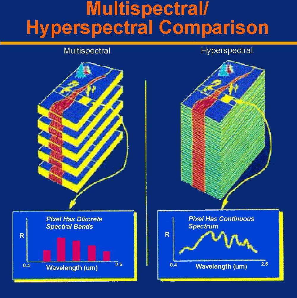
6 Introduction of Technology Multispectral/Hyperspectral Sensing Concept Multispectral/Hyperspectral Systems Spectral Sensing Processing Systems Key Topics Scientific Principles Hyperspectral Imagery Examples Applications National Policy Summary Talk Outline
7 What is Hyperspectral Sensing? Sensor with hundreds of spectral channels with each channel covering a narrow and contiguous portion of the light spectrum Hyperspectral sensing allows the analyst to perform reflectance or fluorescence spectroscopy on each spatial element of the image scene
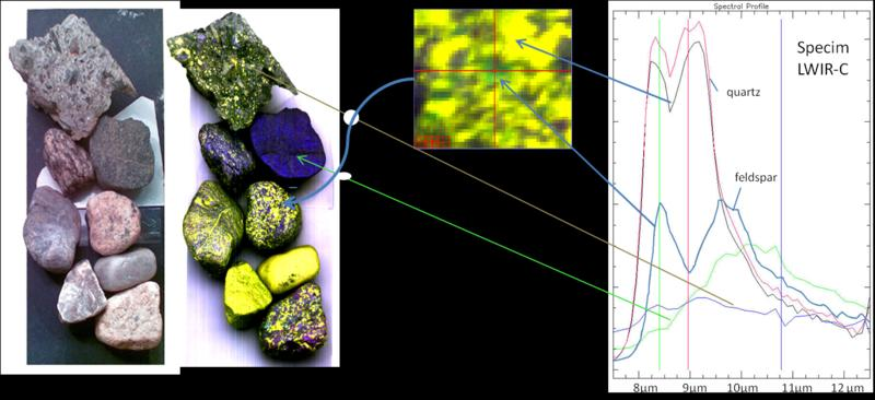
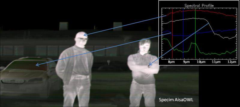
8 Scientific Principles Photons traveling through the Earth s atmosphere strike the surface and are either absorbed, transmitted, scattered and/or reflected Various materials absorb photons over specific wavelength intervals resulting in absorption features in reflectance spectra The location and shape of these unique absorption features provide information on the chemical composition of materials

9 After Elachi, JPL Hyperspectral Sensing Concept
10 Spectral Sensing Broadband Visible SWIR LWIR Multispectral Band Band Band Band Band Band Band Hyperspectral 100s of Bands Ultraspectral 1000s of Bands
11 Hyperspectral Sensing Concept (Cont.) Courtesy of JPL
12
13 Remote Sensing Electromagnetic Spectrum VIS Solar Radiance Back-Scattered from Earth s Surface Black Body Radiation of the earth (300K) 0.3 um 1 um 3 um 10 um 1 mm u 0.7u a VIS 100 NIR SWIR MIR FIR MW Blocked b Human Eye um Wavelength (mm) Photography Radiometers & Imaging Systems Laser Sensors Radars Passive microwave Radiometers
14 Spectral Windows Short Wave Infrared (SWIR) (0.7-2 microns) Long Wave Infrared (LWIR) (8-12 microns) Visible ( microns) Mid Wave Infrared (MWIR) (3-5 microns) Millimeter Wave (MMW) ( microns) wavelength (microns) 10 4 Photons falling between the spectral windows highlighted above are severely attenuated (either absorbed, scattered, or both) by the Earth s atmosphere.

15 USGS Multispectral Imaging

16 USGS Hyperspectral Imaging
17 Classification of Sensors Image Acquisition Modes Whiskbroom Imagers Pushbroom Imagers Staring Imagers Spectral Selection Modes Dispersion Element (grating, prism) Filter-Based Systems Interference Filters Acoustical-Optical Filters Liquid Crystal Tunable Filters (LCTF) Interferometer-Based Systems Michelson Interferometer Fourier Transform Interferometer System Other (e.g., Multi-order etalons)

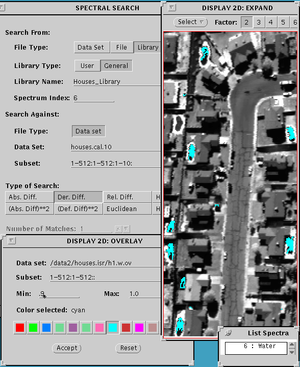
18 Image Acquisition Modes
19 Airborne Hyperspectral Systems 1983 AIS, 10m pixels, 128 bands ( um) - retired 1986 GER 63, 10m pixels, 63 bands ( um) 1987 AVIRIS, 3, 20m pixels, 224 bands ( um) 1989 CASI, 10m pixels, 288 bands ( um) 1993 AISA, 286 bands ( um) 1994 TRWIS III, 242 bands ( m) 1995 HYDICE, 210 bands ( um) 1996 HyperCam, 256 bands ( m) 1997 PROBE-1, 128 bands ( um) 1998 HyMap, 126 bands ( um) 1999 AURORA, 512 bands ( um)
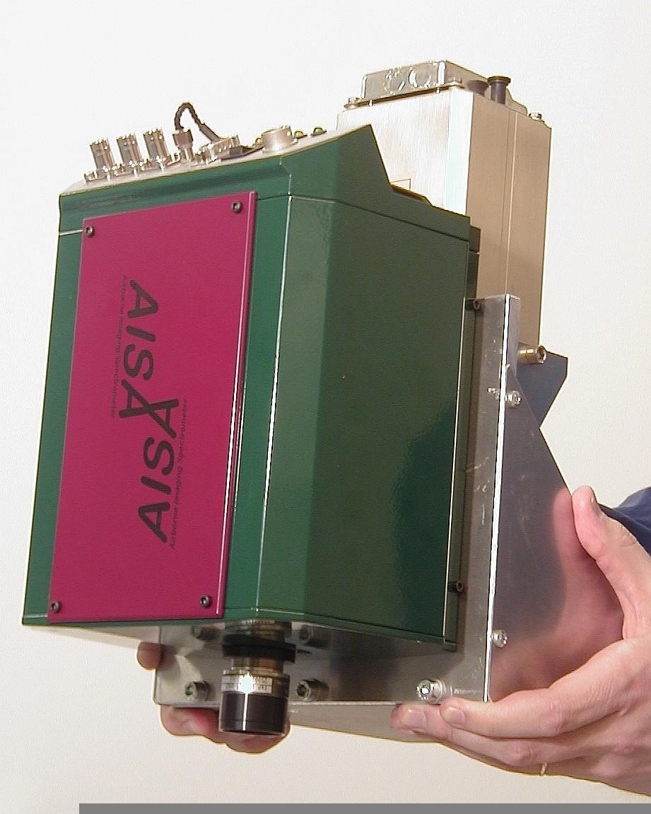
20 AISA Hyperspectral System

21 AURORA Hyperspectral System
22 Spaceborne Hyperspectral Systems Launched in Australian Resource Information and Environment Satellite (ARIES) (Launch date keeps changing) Naval EarthMap Observer (NEMO) Coastal Ocean Imaging Spectrometer (COIS) Likely Program Terminated Orbview 4 (Warfighter 1) Launched: 21 September 2001 (Failed to Orbit) TRW Hyperion (EO-1) Launched: 21 November 2000 AFRL MightySat II.1 (Sindri) - FTHSI Launched: 19 July 2000 Compact High Resolution Imaging Spectrometer (CHRIS) Launched aboard ESA s PROBA satellite on 22 October 2001
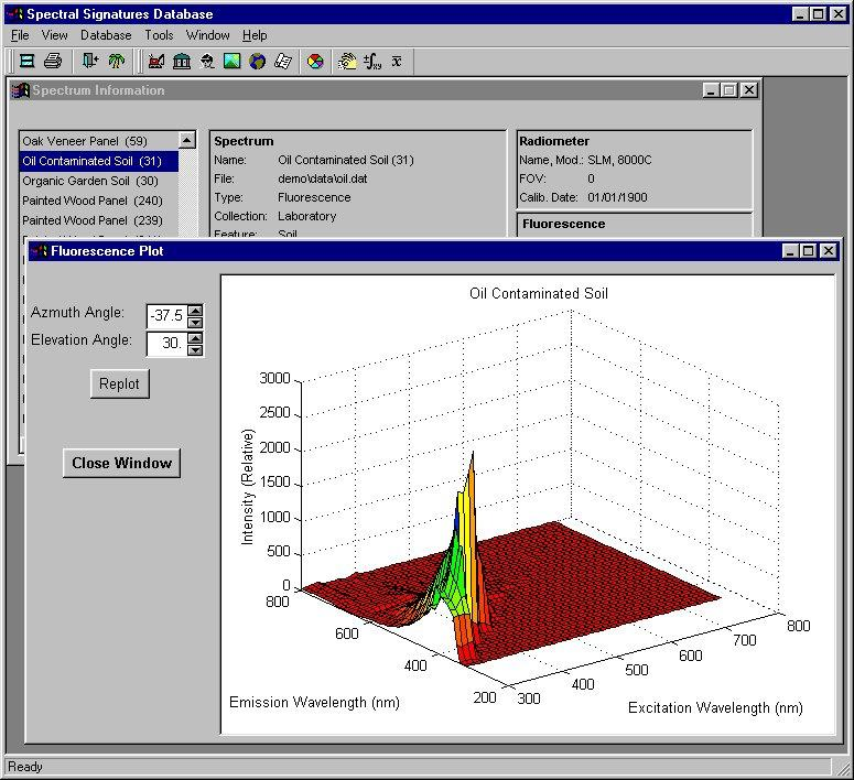
23 Laboratory Measurements


24 Field Measurements Sample field vegetation spectral measurement

25 Image Measurements Reflectance spectrum of a live oak from Ft. Hood Texas Signature extracted from HYDICE imagery using ENVI software
26 Spectral Database Issues Existing spectral libraries are in a wide variety of formats and need to be consolidated A spectral database is an essential tool on which to base future research A spectral database will be absolutely necessary to handle flood of future data A spectral database could be federated with other applicable databases (e.g., Imagery, DEMs, IFSAR, etc.)
27 Data Handling Structure
28 Atmospheric Compensation
29 Atmospheric Compensation (Cont.) Physics based Models Atmospheric REMoval (ATREM) Atmospheric Correction Now (ACORN) Fast Line-of-sight Atmospheric Analysis of Spectral Hypercubes (FLAASH) FLAASH utilizes the Full MODTRAN-4 Semi-Empirical Models Empirical Models
30 After Sam Barr, TEC Hyperspectral Data Processing
31 Spectral Sensing Processing Systems Spectral Analysis Manager (SPAM) JPL Integrated Software for Imaging Spectrometers (ISIS) USGS Flagstaff Hyperspectral Image Processing System (HIPS) U.S. Army TEC Spectral Image Processing System (SIPS) University of Colorado, Boulder SPECtrum Processing Routines (SPECPR) USGS Denver Optical Real-time Adaptive Spectral Identification System (ORASIS) NRL DIMPLE 3.0 RockWare, Inc. Imaging Spectrometer Data Analysis System (ISDAS) CCRS in Canada PCI PCI Remote Sensing Corporation Environment for Visualizing Images (ENVI) Research Systems, Inc. Multispectral Image Data Analysis System (MultiSpec) Purdue University HyperCube U. S. Army TEC ProVIEW Applied Coherent Technology, Inc. ERDAS IMAGINE Commercial package Others
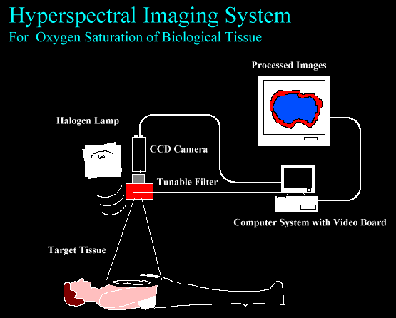
32 Categories of Errors Data Acquisition Errors Data Processing Errors Scene dependent Errors

33 The Pixel Mixing Problem
34 Hyperspectral Sensing Applications Material Identification Environmental (wetlands, land cover, hydrology, etc.) Health Care (food safety, medical diagnoses, etc.) Littoral Studies (bathymetry, water clarity, etc.) Trafficability Analysis Land Mine Detection Plume Analysis Camouflage, Concealment, Detection Biological and Chemical Detection Precision Agriculture/Farming Disaster Mitigation City Planning and Real Estate Law Enforcement Many Others
35 Health Care Applications
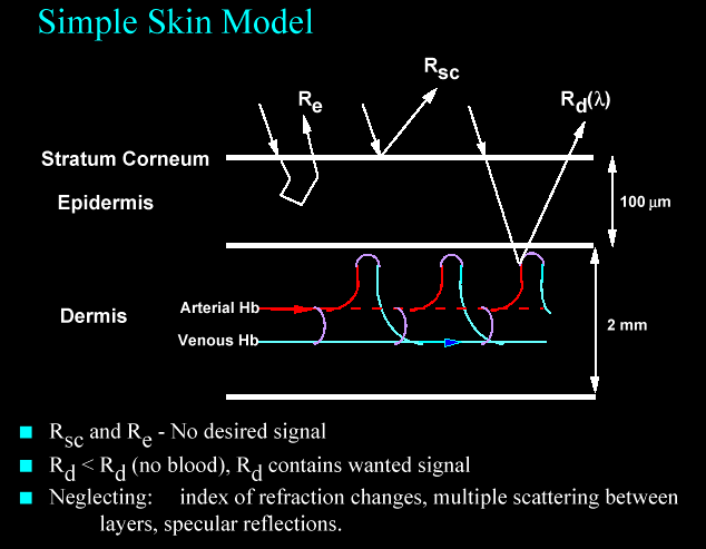

36 Skin Monitoring

37 Monitoring Tissue Physiology Reflectance and fluorescence could be used with a hyperspectral sensor to determine tissue characteristics.

38 Hyperspectral Sensing Pathology Spectral signatures provide fingerprints of many forms of cancer and various neurological and cardiovascular disorders.

39 Monitoring Tissue Physiology Use of hyperspectral imaging to monitor tissue physiology, including tissue oxygenation, respiratory status, and ischemic damage.

40 Clinical Chemistry Hyperspectral Sensing The quantitative reagentless determination of analytes in such common fluids as blood/serum or urine.

41 Automated Chicken Inspection Use of spectral imaging technology for on-line detection of wholesome poultry during slaughter. (Agriculture Research Magazine)

42 Digital Airborne Imaging Spectrometer (DAIS) Aerial oblique view made with DAIS. Shows a natural color image on the left and a SWIRthermal image on the right, of Mount Etna in Sicily, during one of its active periods. Smoke obscures some details of volcanic features in the natural image but not in the SWIR Thermal-IR rendition.
43 Hyperspectral Imagery

44 U.S. Navy Plane in China Real or Fake?
 NASA AVIRIS")


45 Airborne Visual/Infra-Red Imaging Spectrometer (AVIRIS) NASA AVIRIS flights over Cuprite, Nevada. The JPL and the Spectroscopy Group at the U.S. Geological Survey in Denver reduced and manipulated the data.
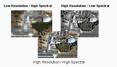

46 Hyperspectral Data Fusion

47 Spectral Sensing Research Objectives Evaluate/Validate Hyperspectral Imagery (HSI) Technology in Realistic Environments Demonstrate Utility of Space-Based, Airborne, and Ground HSI Sensors to Users in Remote Sensing Community Demonstrate Ability to Leverage Commercial and Military HSI Systems to Meet User s Needs Develop User-Friendly Ways to Manage, Fuse, House, Distribute, and Exploit Spectral Sensor Data OrbView-4 Spacecraft
48 Data Infrastructure Program Objectives Design and develop a relational database that is capable of managing large amounts of diverse spectral data (Vis-NIR, Thermal, Fluorescence, ultraviolet) Develop query and visualization tools to perform common functions for both expert and novice users Develop and incorporate application software to perform advanced analysis (e.g., band selection, signature matching)
49 Spectral Database Requirements Existing spectral libraries are in a wide variety of formats and need to be consolidated A spectral database is an essential tool on which to base future research A spectral database will be absolutely necessary to handle flood of future data A spectral database could be federated with other applicable databases (e.g., Imagery, DEMs, IFSAR, etc.)
 Need Standards, Definitions, Policies, and")
50 Summary Hyperspectral Imaging (HSI) is a Mature Technology Sensor and Data Fusion is the way to go Data Collection, Storage, and Usage Methods are Currently Inefficient Crucial Data are Costly and Hard to Find Need for Accessible, Up-to-Date, Relevant, Accurate, Timely, and User- Friendly Digital Spectral Information Library (Spectral Data Bank) Need Standards, Definitions, Policies, and Collaborations Emphasis Needs to be Placed in Training the Workforce

51 Comparing Apples to Oranges Opto-Knowledge Systems, Inc.
52
53
54
55
56
57


58 Obserwacje optyczne wysokiej rozdzielczości spektralnej w zakresie IR i VIS

59 Obserwacje optyczne wysokiej rozdzielczości spektralnej w zakresie IR i VIS MODerate resolution Imaging Spectroradiometer


60 Obserwacje optyczne wysokiej rozdzielczości spektralnej w zakresie IR i VIS MODerate resolution Imaging Spectroradiometer


61 Obserwacje optyczne wysokiej rozdzielczości spektralnej w zakresie IR i VIS MODerate resolution Imaging Spectroradiometer
62 Obserwacje optyczne wysokiej rozdzielczości spektralnej w zakresie IR i VIS MODerate resolution Imaging Spectroradiometer Pasmo Długość fali (mikrometr) 1 0,62-0, ,841-0, ,459-0, ,545-0, ,23-1, ,628-1, ,105-2, ,405-0, ,438-0, ,483-0, ,526-0, ,546-0, ,662-0, ,673-0, ,743-0, ,862-0, ,89-0, ,931-0, Rozdzielczość (metr)

63 Obserwacje optyczne wysokiej rozdzielczości spektralnej w zakresie IR i VIS MODerate resolution Imaging Spectroradiometer 19 0,915-0, ,66-3, ,929-3, ,929-3, ,02-4, ,433-4, ,482-4, ,36-1, ,535-6, ,175-7, ,4-8, ,58-9, ,78-11, ,77-12, ,185-13, ,485-13, ,785-14, ,085-14,

64 Obserwacje optyczne wysokiej rozdzielczości spektralnej w zakresie IR i VIS MODerate resolution Imaging Spectroradiometer

65 Obserwacje optyczne wysokiej rozdzielczości spektralnej w zakresie IR i VIS MODerate resolution Imaging Spectroradiometer

66 Obserwacje optyczne wysokiej rozdzielczości spektralnej w zakresie IR i VIS MODerate resolution Imaging Spectroradiometer Wskaźnik produkcji pierwotnej biomasy

67 Obserwacje optyczne wysokiej rozdzielczości spektralnej w zakresie IR i VIS MODerate resolution Imaging Spectroradiometer Różnice temperatur w Australi ( )

68 Obserwacje optyczne wysokiej rozdzielczości spektralnej w zakresie IR i VIS MODerate resolution Imaging Spectroradiometer Dwie góry lodowe odrywające się od Antarktydy ( )

69 Obserwacje optyczne wysokiej rozdzielczości spektralnej w zakresie IR i VIS MODerate resolution Imaging Spectroradiometer Biegun północny
70 Obserwacje optyczne wysokiej rozdzielczości spektralnej w zakresie IR i VIS MODerate resolution Imaging Spectroradiometer Biegun północny JZc

71 Obserwacje optyczne wysokiej rozdzielczości spektralnej w zakresie IR i VIS MODerate resolution Imaging Spectroradiometer Tropikalne cyklony Thomas i Ului ( )

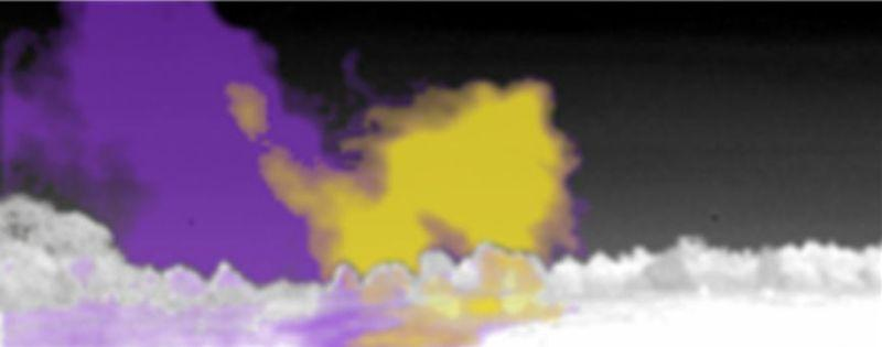
72 Obserwacje optyczne wysokiej rozdzielczości spektralnej w zakresie IR i VIS MODerate resolution Imaging Spectroradiometer Pył nad Chinami ( )
The Overview of Civilian Applications of Airborne SAR Systems
 The Overview of Civilian Applications of Airborne SAR Systems Maciej Smolarczyk, Piotr Samczyński Andrzej Gadoś, Maj Mordzonek Research and Development Department of PIT S.A. PART I WHAT DOES SAR MEAN?
OPBOX ver USB 2.0 Mini Ultrasonic Box with Integrated Pulser and Receiver
 OPBOX ver.0 USB.0 Mini Ultrasonic Box with Integrated Pulser and Receiver Przedsiębiorstwo BadawczoProdukcyjne OPTEL Sp. z o.o. ul. Morelowskiego 30 PL59 Wrocław phone: +8 7 39 8 53 fax.: +8 7 39 8 5 email:
Rejestracja lotniczych obrazów hiperspektralnych
 Rejestracja lotniczych obrazów hiperspektralnych Zobrazowania hiperspektralne są definiowane jako równoczesne pozyskanie obrazów w wielu bardzo wąskich, ciągłych zakresach spektralnych (Goetz i inni, 1985).
TELEDETEKCJA ŚRODOWISKA dawniej FOTOINTERPRETACJA W GEOGRAFII. Tom 51 (2014/2)
") TELEDETEKCJA ŚRODOWISKA dawniej FOTOINTERPRETACJA W GEOGRAFII Półrocznik Tom 51 (2014/2) POLSKIE TOWARZYSTWO GEOGRAFICZNE Oddział Teledetekcji i Geoinformatyki WARSZAWA www.ptg.pan.pl./?teledetekcja_%a6rodowiska
TELEDETEKCJA ŚRODOWISKA dawniej FOTOINTERPRETACJA W GEOGRAFII Półrocznik Tom 51 (2014/2) POLSKIE TOWARZYSTWO GEOGRAFICZNE Oddział Teledetekcji i Geoinformatyki WARSZAWA www.ptg.pan.pl./?teledetekcja_%a6rodowiska
Cel szkolenia. Konspekt
 Cel szkolenia About this CourseThis 5-day course provides administrators with the knowledge and skills needed to deploy and ma Windows 10 desktops, devices, and applications in an enterprise environment.
Menu. Obserwacje optyczne wysokiej rozdzielczości
 Menu Obserwacje optyczne wysokiej rozdzielczości Historia Jeszcze kilkadziesiąt lat temu obrazy Błękitnej Planety służyły nam niemal wyłącznie do celów artystycznych. Jednak w ciągu ostatnich 10 lat rozdzielczość
Menu. Do badań zabarwienia oceanów,
 Menu Do badań zabarwienia oceanów, Instrumenty do badań zabarwienia oceanów Radiometry i spektrometry obrazowe pracujące w zakresie widzialnym i blisko widma IR w zakresie 400-800 nm. Dla tych długości
Forested areas in Cracow ( ) evaluation of changes based on satellite images 1 / 31 O
 evaluation of changes based on satellite images 1 / 31 O") Forested areas in Cracow (1985-2017) evaluation of changes based on satellite images Obszary leśne w Krakowie (1985-2017) szacowanie zmian na podstawie zobrazowań satelitarnych Cracow University of Technology
Forested areas in Cracow (1985-2017) evaluation of changes based on satellite images Obszary leśne w Krakowie (1985-2017) szacowanie zmian na podstawie zobrazowań satelitarnych Cracow University of Technology
deep learning for NLP (5 lectures)
") TTIC 31210: Advanced Natural Language Processing Kevin Gimpel Spring 2019 Lecture 6: Finish Transformers; Sequence- to- Sequence Modeling and AJenKon 1 Roadmap intro (1 lecture) deep learning for NLP (5
TTIC 31210: Advanced Natural Language Processing Kevin Gimpel Spring 2019 Lecture 6: Finish Transformers; Sequence- to- Sequence Modeling and AJenKon 1 Roadmap intro (1 lecture) deep learning for NLP (5
Electromagnetism Q =) E I =) B E B. ! Q! I B t =) E E t =) B. 05/06/2018 Physics 0
 E I =) B E B. ! Q! I B t =) E E t =) B. 05/06/2018 Physics 0") lectromagnetism lectromagnetic interaction is one of four fundamental interactions in Nature. lectromagnetism is the theory of electromagnetic interactions or of electromagnetic forces. lectric charge
lectromagnetism lectromagnetic interaction is one of four fundamental interactions in Nature. lectromagnetism is the theory of electromagnetic interactions or of electromagnetic forces. lectric charge
Zdjęcia satelitarne w badaniach środowiska przyrodniczego
 Zdjęcia satelitarne w badaniach środowiska przyrodniczego Maria Andrzejewska, UNEP/GRID-Warszawa Program zajęć PRZYPOMNIENIE I UPORZĄDKOWANIE WIADOMOŚCI w zakresie zobrazowań satelitarnych rodzaje satelitów
Auditorium classes. Lectures
 Faculty of: Mechanical and Robotics Field of study: Mechatronic with English as instruction language Study level: First-cycle studies Form and type of study: Full-time studies Annual: 2016/2017 Lecture
Spektroskopia Ramanowska
 Spektroskopia Ramanowska Część A 1.Krótki wstęp historyczny 2.Oddziaływanie światła z osrodkiem materialnym (rozpraszanie światła) 3.Opis klasyczny zjawiska Ramana 4. Widmo ramanowskie. 5. Opis półklasyczny
Sargent Opens Sonairte Farmers' Market
 Sargent Opens Sonairte Farmers' Market 31 March, 2008 1V8VIZSV7EVKIRX8(1MRMWXIVSJ7XEXIEXXLI(ITEVXQIRXSJ%KVMGYPXYVI *MWLIVMIWERH*SSHTIVJSVQIHXLISJJMGMEPSTIRMRKSJXLI7SREMVXI*EVQIVW 1EVOIXMR0E]XS[R'S1IEXL
Temporal identification of poppy fields on high resolution satellite imagery
 Temporal identification of poppy fields on high resolution satellite imagery Marc Rußwurm marc.russwurm@tum.de Michał Krupiński mkrupinski@cbk.waw.pl Stanisław Lewiński stlewinski@cbk.waw.pl Introduction
Podstawy Geomatyki Wykład VI Teledetekcja 1
 Podstawy Geomatyki Wykład VI Teledetekcja 1 Teledetekcja (Remote Sensing) - definicja [remote sensing] «Collecting and interpreting information about the environment and the surface of the earth from a
Automatyzacja teleskopu Celestron CGE Pro w OA UJ
 Automatyzacja teleskopu Celestron CGE Pro w OA UJ tomasz.szymanski@oa.uj.edu.pl Tomasz Szymański Obserwatorium Astronomiczne Uniwersytetu Jagiellońskiego 3-04-2012 Plan 1 Schemat modelu 2 Sprzęt 3 Oprogramowanie
MS OD Integrating MDM and Cloud Services with System Center Configuration Manager
 MS OD20703-2 - Integrating MDM and Cloud Services with System Center Configuration Manager Czas trwania: Czas trwania: 3 dni / 24 godz. Cena rynkowa: 1 840,00 zł Cena promocyjna: Zadzwoń - 801 30 30 30
We bring all EO Data to user. Copyright ESA Pierre Carril
 We bring all EO Data to user Copyright ESA Pierre Carril WE BRING EO DATA TO USER Standardowa oferta Oferta EO CLOUD Użytkownicy zainteresowani dostępem oraz przetwarzaniem danych EO ściągali dane na urządzenia
KATALOG SZKOLEŃ. Windows Server 2016 Liczba dni STYCZEŃ LUTY MARZEC KWIECIEŃ MAJ CZERWIEC
 Windows Server 2016 Liczba dni STYCZEŃ LUTY MARZEC KWIECIEŃ MAJ CZERWIEC MS-20740 Installation, Storage, and Compute with Windows Server 2016 5 8, 29 19 13 9 7 4, 25 MS-20741 Networking with Windows Server
Proposal of thesis topic for mgr in. (MSE) programme in Telecommunications and Computer Science
 programme in Telecommunications and Computer Science") Proposal of thesis topic for mgr in (MSE) programme 1 Topic: Monte Carlo Method used for a prognosis of a selected technological process 2 Supervisor: Dr in Małgorzata Langer 3 Auxiliary supervisor: 4
Proposal of thesis topic for mgr in (MSE) programme 1 Topic: Monte Carlo Method used for a prognosis of a selected technological process 2 Supervisor: Dr in Małgorzata Langer 3 Auxiliary supervisor: 4
Zarządzanie sieciami telekomunikacyjnymi
 SNMP Protocol The Simple Network Management Protocol (SNMP) is an application layer protocol that facilitates the exchange of management information between network devices. It is part of the Transmission
Liczba punktów ECTS za zajęcia praktyczne. Liczba punktów ECTS. udziałem nauczyciela akademickiego. samodzielna praca. z bezpośrednim.
 udziałem nauczyciela za zajęcia praktyczne Rodzaj zajęć (A, P, CT, Pr, PD)*** Obszar nauk: technicznych - T, Plan studiów obowiązujący od roku 2019/2020 na kierunku: Geodezja i Kartografia Profil kształcenia:
Extraclass. Football Men. Season 2009/10 - Autumn round
 Extraclass Football Men Season 2009/10 - Autumn round Invitation Dear All, On the date of 29th July starts the new season of Polish Extraclass. There will be live coverage form all the matches on Canal+
TTIC 31210: Advanced Natural Language Processing. Kevin Gimpel Spring Lecture 9: Inference in Structured Prediction
 TTIC 31210: Advanced Natural Language Processing Kevin Gimpel Spring 2019 Lecture 9: Inference in Structured Prediction 1 intro (1 lecture) Roadmap deep learning for NLP (5 lectures) structured prediction
Remote Sensing & Photogrammetry L6. Beata Hejmanowska Building C4, room 212, phone:
 Remote Sensing & Photogrammetry L6 Beata Hejmanowska Building C4, room 212, phone: +4812 617 22 72 605 061 510 galia@agh.edu.pl Image processing 1. Visual interpretation of single spectral band Readout
Wybrane trendy i nowości z Kongresu ISPRS 16
 WYDZIAŁ GEODEZJI I KRATOGRAFII P O L I T E C H N I K A W A R S Z A W S K A Wybrane trendy i nowości z Kongresu ISPRS 16 Joanna Pluto-Kossakowska, Helena Łoś Zakład Fotogrametrii, Teledetekcji i Systemów
GLOBAL METHANE INITIATIVE PARTNERSHIP-WIDE MEETING 12-14.10.2011 Kraków, Poland
 GLOBAL METHANE INITIATIVE PARTNERSHIP-WIDE MEETING 12-14.10.2011 Kraków, Poland INSTITUTE OF TECHNOLOGY AND LIVE SCIENCES POZNAŃ BRANCH Department of Environmental Management in Livestock Buildings and
No matter how much you have, it matters how much you need
 CSR STRATEGY KANCELARIA FINANSOWA TRITUM GROUP SP. Z O.O. No matter how much you have, it matters how much you need Kancelaria Finansowa Tritum Group Sp. z o.o. was established in 2007 we build trust among
Misje Kosmiczne ESA Cosmic Vision Program
 Misje klasy S - małe Misje Kosmiczne ESA Cosmic Vision Program Misje klasy M średnie Misje klasy L - duże Wybór tematu badawczego misji i propozycje instrumentów Misje Kosmiczne ESA Preliminary Requirements
Raport bieżący: 44/2018 Data: g. 21:03 Skrócona nazwa emitenta: SERINUS ENERGY plc
 Raport bieżący: 44/2018 Data: 2018-05-23 g. 21:03 Skrócona nazwa emitenta: SERINUS ENERGY plc Temat: Zawiadomienie o zmianie udziału w ogólnej liczbie głosów w Serinus Energy plc Podstawa prawna: Inne
DETECTION OF MATERIAL INTEGRATED CONDUCTORS FOR CONNECTIVE RIVETING OF FUNCTION-INTEGRATIVE TEXTILE-REINFORCED THERMOPLASTIC COMPOSITES
 Kompozyty 11: 2 (2011) 152-156 Werner A. Hufenbach, Frank Adam, Maik Gude, Ivonne Körner, Thomas Heber*, Anja Winkler Technische Universität Dresden, Institute of Lightweight Engineering and Polymer Technology
Podstawa prawna: Art. 70 pkt 1 Ustawy o ofercie - nabycie lub zbycie znacznego pakietu akcji
 Raport bieżący: 41/2018 Data: 2018-05-22 g. 08:01 Skrócona nazwa emitenta: SERINUS ENERGY plc Temat: Przekroczenie progu 5% głosów w SERINUS ENERGY plc Podstawa prawna: Art. 70 pkt 1 Ustawy o ofercie -
Wyjazdy dla studentów Politechniki Krakowskiej zainteresowanych studiami częściowymi w Tianjin Polytechnic University (Chiny).
.") Wyjazdy dla studentów Politechniki Krakowskiej zainteresowanych studiami częściowymi w Tianjin Polytechnic University (Chiny). Tianjin Polytechnic University (TJPU) jest państwową uczelnią chińską założoną
Wyjazdy dla studentów Politechniki Krakowskiej zainteresowanych studiami częściowymi w Tianjin Polytechnic University (Chiny). Tianjin Polytechnic University (TJPU) jest państwową uczelnią chińską założoną
IBM Skills Academy SZKOLENIA I CERTYFIKATY
 IBM SKILLS ACADEMY IBM Skills Academy SZKOLENIA I CERTYFIKATY PROGRAM SZKOLENIOWY IBM Elitarny program certyfikacyjny dla studentów i pracowników najlepszych uczelni kształcących na kierunkach IT 2014
QGIS w nietypowych zastosowaniach
 QGIS w nietypowych zastosowaniach Robert Szczepanek Politechnika Krakowska OSGeo / QGIS Polska V ŚLĄSKI KONWENT INFORMATYKÓW I ADMINISTRACJI Szczyrk 11-12 czerwca 2015 Robert Szczepanek QGIS w nietypowych
Streszczenie rozprawy doktorskiej
 Doskonalenie pomiaru zawartości wody w produktach spożywczych z wykorzystaniem metody wagosuszarkowej bazującej na promieniowaniu IR mgr Sławomir Janas Streszczenie rozprawy doktorskiej Promotor pracy:
The shape of and the challenges for the Polish EO sector initial findings of the SEED EO project
 The shape of and the challenges for the Polish EO sector initial findings of the SEED EO project Drugie Forum Obserwacji Ziemi Ministerstwo Rozwoju Warszawa, 4 lipca 2016 2 Zadania projektu Stworzenie
WYDZIAŁ NAUK EKONOMICZNYCH. Studia II stopnia niestacjonarne Kierunek Międzynarodowe Stosunki Gospodarcze Specjalność INERNATIONAL LOGISTICS
 Studia II stopnia niestacjonarne Kierunek Międzynarodowe Stosunki Gospodarcze Specjalność INERNATIONAL LOGISTICS Description Master Studies in International Logistics is the four-semesters studies, dedicate
No. of subject Subject ECTS. Employees of the Institute of Textile Engineering and Polymer Materials (I_21)
") dla studentów zagranicznych, którzy w ramach dostępnych programów europejskich, realizują część toku kształcenia w Akademii Techniczno-Humanistycznej w Bielsku-Białej Employees of the Institute of Textile
dla studentów zagranicznych, którzy w ramach dostępnych programów europejskich, realizują część toku kształcenia w Akademii Techniczno-Humanistycznej w Bielsku-Białej Employees of the Institute of Textile
Podstawy Geomatyki Wykład VI Teledetekcja 2. Remote sensing methods based on multispectral satellite images (passive methods)
") Podstawy Geomatyki Wykład VI Teledetekcja 2 Remote sensing methods based on multispectral satellite images (passive methods) Obrazowanie optyczne Podstawowa metoda teledetekcji pasywnej zobrazowania multispektralne
Podstawy Geomatyki Wykład VI Teledetekcja 2 Remote sensing methods based on multispectral satellite images (passive methods) Obrazowanie optyczne Podstawowa metoda teledetekcji pasywnej zobrazowania multispektralne
Why do I need a CSIRT?
 Przemyslaw Jaroszewski CERT Polska Przemyslaw.Jaroszewski@cert.pl Przemyslaw.Jaroszewski@cert.pl Slide: 1 Why bother with security? (1) Security threats are real Windows server from the box has CodeRed
Metodyki projektowania i modelowania systemów Cyganek & Kasperek & Rajda 2013 Katedra Elektroniki AGH
 Kierunek Elektronika i Telekomunikacja, Studia II stopnia Specjalność: Systemy wbudowane Metodyki projektowania i modelowania systemów Cyganek & Kasperek & Rajda 2013 Katedra Elektroniki AGH Zagadnienia
Formularz recenzji magazynu. Journal of Corporate Responsibility and Leadership Review Form
 Formularz recenzji magazynu Review Form Identyfikator magazynu/ Journal identification number: Tytuł artykułu/ Paper title: Recenzent/ Reviewer: (imię i nazwisko, stopień naukowy/name and surname, academic
 www.irs.gov/form990. If "Yes," complete Schedule A Schedule B, Schedule of Contributors If "Yes," complete Schedule C, Part I If "Yes," complete Schedule C, Part II If "Yes," complete Schedule C, Part
FORMULARZ DLA OGŁOSZENIODAWCÓW
 FORMULARZ DLA OGŁOSZENIODAWCÓW INSTYTUCJA: Uniwersytet Kazimierza Wielkiego, Wydział Administracji i Nauk Społecznych, Katedra Informacji Naukowej i Bibliologii. MIASTO: Bydgoszcz STANOWISKO: adiunkt DYSCYPLINA
I INTERNATIONAL SCIENTIFIC CONFERENCE
 I INTERNATIONAL SCIENTIFIC CONFERENCE EU SECURITY AND CRISIS MANAGEMENT FLOOD-2010 ATENEUM UNIVERSITY IN GDANSK P FUNDATION PRO POMERANIA NOTICE NO. 1 I International Scientific Conference EU SECURITY
Network Services for Spatial Data in European Geo-Portals and their Compliance with ISO and OGC Standards
 INSPIRE Conference 2010 INSPIRE as a Framework for Cooperation Network Services for Spatial Data in European Geo-Portals and their Compliance with ISO and OGC Standards Elżbieta Bielecka Agnieszka Zwirowicz
TTIC 31210: Advanced Natural Language Processing. Kevin Gimpel Spring Lecture 8: Structured PredicCon 2
 TTIC 31210: Advanced Natural Language Processing Kevin Gimpel Spring 2019 Lecture 8: Structured PredicCon 2 1 Roadmap intro (1 lecture) deep learning for NLP (5 lectures) structured predic+on (4 lectures)
TAROPAK SCHEDULE 2010. 13 September 2010, Monday
 TAROPAK SCHEDULE 2010 13 September 2010, Monday Spedycja, Used Forklift Market 10.15-15.00 PIO Promotion Showroom Chamber of Packaging, 10.15 Opening ceremony of the Promotion Showroom and the stand of
Współczesne Trendy w Informatyce a Komputeryzacja Działalności Leczniczej Current IT trends and health care computerization
 Współczesne Trendy w Informatyce a Komputeryzacja Działalności Leczniczej Current IT trends and health care computerization Autor: Stefan Cieśla Rok 2011 przełomowy rok w usługach zdrowotnych. 1. Wprowadzono
 www.irs.gov/form990. If "Yes," complete Schedule A Schedule B, Schedule of Contributors If "Yes," complete Schedule C, Part I If "Yes," complete Schedule C, Part II If "Yes," complete Schedule C, Part
Zakopane, plan miasta: Skala ok. 1: = City map (Polish Edition)
") Zakopane, plan miasta: Skala ok. 1:15 000 = City map (Polish Edition) Click here if your download doesn"t start automatically Zakopane, plan miasta: Skala ok. 1:15 000 = City map (Polish Edition) Zakopane,
Zakopane, plan miasta: Skala ok. 1:15 000 = City map (Polish Edition) Click here if your download doesn"t start automatically Zakopane, plan miasta: Skala ok. 1:15 000 = City map (Polish Edition) Zakopane,
THE ADMISSION APPLICATION TO PRIVATE PRIMARY SCHOOL. PART I. Personal information about a child and his/her parents (guardians) Child s name...
 Child s name...") THE ADMISSION APPLICATION TO PRIVATE PRIMARY SCHOOL PART I. Personal information about a child and his/her parents (guardians) Child s name... Child s surname........ Date and place of birth..... Citizenship.....
THE ADMISSION APPLICATION TO PRIVATE PRIMARY SCHOOL PART I. Personal information about a child and his/her parents (guardians) Child s name... Child s surname........ Date and place of birth..... Citizenship.....
MoA-Net: Self-supervised Motion Segmentation. Pia Bideau, Rakesh R Menon, Erik Learned-Miller
 MoA-Net: Self-supervised Motion Segmentation Pia Bideau, Rakesh R Menon, Erik Learned-Miller University of Massachusetts Amherst College of Information and Computer Science Motion Segmentation P Bideau,
Mechanizmy wspierania rozwoju programu Galileo w innych krajach. Wybrane przykłady
 Mechanizmy wspierania rozwoju programu Galileo w innych krajach Wybrane przykłady GATE - German GAlileo Test and Development Environment Centrum testowania Galileo Czas działania 2006-2010 Finansowanie:German
Krytyczne czynniki sukcesu w zarządzaniu projektami
 Seweryn SPAŁEK Krytyczne czynniki sukcesu w zarządzaniu projektami MONOGRAFIA Wydawnictwo Politechniki Śląskiej Gliwice 2004 SPIS TREŚCI WPROWADZENIE 5 1. ZARZĄDZANIE PROJEKTAMI W ORGANIZACJI 13 1.1. Zarządzanie
Wojewodztwo Koszalinskie: Obiekty i walory krajoznawcze (Inwentaryzacja krajoznawcza Polski) (Polish Edition)
 (Polish Edition)") Wojewodztwo Koszalinskie: Obiekty i walory krajoznawcze (Inwentaryzacja krajoznawcza Polski) (Polish Edition) Robert Respondowski Click here if your download doesn"t start automatically Wojewodztwo Koszalinskie:
Wojewodztwo Koszalinskie: Obiekty i walory krajoznawcze (Inwentaryzacja krajoznawcza Polski) (Polish Edition) Robert Respondowski Click here if your download doesn"t start automatically Wojewodztwo Koszalinskie:
ZGŁOSZENIE WSPÓLNEGO POLSKO -. PROJEKTU NA LATA: APPLICATION FOR A JOINT POLISH -... PROJECT FOR THE YEARS:.
 ZGŁOSZENIE WSPÓLNEGO POLSKO -. PROJEKTU NA LATA: APPLICATION FOR A JOINT POLISH -... PROJECT FOR THE YEARS:. W RAMACH POROZUMIENIA O WSPÓŁPRACY NAUKOWEJ MIĘDZY POLSKĄ AKADEMIĄ NAUK I... UNDER THE AGREEMENT
3.
 1 2 3 4. :.1 1392 1390..2 m.adib@sbu.ac.ir 3. mkzadeh@gmail.com ) 1385 15. (..4 yousefi.mary@gmail.com....... 134. 22. 1347 1389 1391. 1392. .. 1392 1389.. 5... 6 : (4 (3 (2 (1 (5 (10 (9 (8 (7 (6 (14 (13
School of Applied Sciences: Manufacturing & Materials
 School of Applied Sciences: Manufacturing & Materials The UK s University for Business Dr. Jeff Rao MSc courses in MMD Advanced Materials Aerospace Materials 8 modules + group & individual project To develop
PLANY I PROGRAMY STUDIÓW
 WYDZIAŁ INŻYNIERII PRODUKCJI I LOGISTYKI PLANY I PROGRAMY STUDIÓW STUDY PLANS AND PROGRAMS KIERUNEK STUDIÓW FIELD OF STUDY - INŻYNIERIA BEZPIECZEŃSTWA - SECURITY ENGINEERING Studia stacjonarne pierwszego
Assignment 3.1 (SA and LA)
") AW 11 Name u J2T0v1V9g XKru_ttaF NS^oQfOtXwUagr\eu GLHLOC^.F C XAqldlO FrEiIg\hXtHsO xrcewsqeprtvheed`. Assignment 3.1 (SA and LA) Find the area of each. 1) 11 m 2) 6.5 m 5 km 2.9 km 3) 4) 4.3 ft 6.2 km
AW 11 Name u J2T0v1V9g XKru_ttaF NS^oQfOtXwUagr\eu GLHLOC^.F C XAqldlO FrEiIg\hXtHsO xrcewsqeprtvheed`. Assignment 3.1 (SA and LA) Find the area of each. 1) 11 m 2) 6.5 m 5 km 2.9 km 3) 4) 4.3 ft 6.2 km
Unit of Social Gerontology, Institute of Labour and Social Studies ageing and its consequences for society
 Prof. Piotr Bledowski, Ph.D. Institute of Social Economy, Warsaw School of Economics local policy, social security, labour market Unit of Social Gerontology, Institute of Labour and Social Studies ageing
An evaluation of GoldAnchor intraprostatic fiducial marker stability during the treatment planning
 An evaluation of GoldAnchor intraprostatic fiducial marker stability during the treatment planning Dawid Bodusz, Wojciech Leszczyński, Wioletta Miśta, Leszek Miszczyk Application of fiducial gold markers:
WARSZAWA LIX Zeszyt 257
 WARSZAWA LIX Zeszyt 257 SPIS TRE CI STRESZCZENIE... 9 WYKAZ SKRÓTÓW... 10 1. WPROWADZENIE... 13 2. MIKROSKOPIA SI ATOMOWYCH PODSTAWY... 17 2.1. Podstawy oddzia ywa ostrze próbka... 23 2.1.1. Modele fizyczne
INSPECTION METHODS FOR QUALITY CONTROL OF FIBRE METAL LAMINATES IN AEROSPACE COMPONENTS
 Kompozyty 11: 2 (2011) 130-135 Krzysztof Dragan 1 * Jarosław Bieniaś 2, Michał Sałaciński 1, Piotr Synaszko 1 1 Air Force Institute of Technology, Non Destructive Testing Lab., ul. ks. Bolesława 6, 01-494
Wpływ dyrektywy PSD II na korzystanie z instrumentów płatniczych. Warszawa, 15 stycznia 2015 r. Zbigniew Długosz
 Wpływ dyrektywy PSD II na korzystanie z instrumentów płatniczych Warszawa, 15 stycznia 2015 r. Zbigniew Długosz 1 do czego można wykorzystywać bankowość elektroniczną? nowe usługi płatnicze a korzystanie
PN-ISO 10843:2002/AC1
 POPRAWKA do POLSKIEJ NORMY ICS 17.140.20 PN-ISO 10843:2002/AC1 Wprowadza ISO 10843:1997/AC1:2009, IDT Akustyka Metody opisu i pomiaru pojedynczych impulsów lub serii impulsów Poprawka do Normy Międzynarodowej
publiczne / naukowe / pedagogiczne / pedagogical research public
 Działalności podstawowej Library staff Pracownia Bibliotekoznawstwa Instytut Książki i Czytelnictwa BN Zestawienie zbiorcze o stanie i działalności bibliotek w 2016 r. Performance of libraries in 2016
 www.irs.gov/form990. If "Yes," complete Schedule A Schedule B, Schedule of Contributors If "Yes," complete Schedule C, Part I If "Yes," complete Schedule C, Part II If "Yes," complete Schedule C, Part
EXAMPLES OF CABRI GEOMETRE II APPLICATION IN GEOMETRIC SCIENTIFIC RESEARCH
 Anna BŁACH Centre of Geometry and Engineering Graphics Silesian University of Technology in Gliwice EXAMPLES OF CABRI GEOMETRE II APPLICATION IN GEOMETRIC SCIENTIFIC RESEARCH Introduction Computer techniques
Helena Boguta, klasa 8W, rok szkolny 2018/2019
 Poniższy zbiór zadań został wykonany w ramach projektu Mazowiecki program stypendialny dla uczniów szczególnie uzdolnionych - najlepsza inwestycja w człowieka w roku szkolnym 2018/2019. Składają się na
publiczne / naukowe / pedagogiczne / pedagogical research public
 Pracownia Bibliotekoznawstwa Instytut Książki i Czytelnictwa BN Zestawienie zbiorcze o stanie i działalności bibliotek w 2015 r. Performance of libraries in 2015 Opracowano na podstawie danych Głównego
Działania w dziedzinie klimatu, środowisko, efektywna gospodarka zasobami i surowce
 HORIZON 2020 - THE FRAMEWORK PROGRAMME FOR RESEARCH AND INNOVATION (2014-2020) 2020) Challenge 5 Climate action, environment, resource efficiency and raw materials INFORMAL DRAFT 1 Copyright KPK PB UE
WYZWANIA RAPORTOWANIA ZINTEGROWANEGO RAPORTOWANIE NIEFINANSOWE W POLSCE
 WYZWANIA RAPORTOWANIA ZINTEGROWANEGO RAPORTOWANIE NIEFINANSOWE W POLSCE Richard Howitt CEO International Integrated Reporting Council Zintegrowane Raportowanie w Polsce International Integrated Reporting
archivist: Managing Data Analysis Results
 archivist: Managing Data Analysis Results https://github.com/pbiecek/archivist Marcin Kosiński 1,2, Przemysław Biecek 2 1 IT Research and Development Grupa Wirtualna Polska 2 Faculty of Mathematics, Informatics
Recent Developments in Poland: Higher Education Reform Qualifications Frameworks Environmental Studies
 544524-TEMPUS-1-2013-1-PL-TEMPUS-SMHES Qualifications Frameworks for Environmental Studies at Ukrainian Universities Recent Developments in Poland: Higher Education Reform Qualifications Frameworks Environmental
MATERIAŁY DYDAKTYCZNE DO PRZEDMIOTU REMOTE SENSING AND PHOTOINTERPRETATION
 MATERIAŁY DYDAKTYCZNE DO PRZEDMIOTU REMOTE SENSING AND PHOTOINTERPRETATION Wydział Inżynierii Środowiska, Geomatyki i Energetyki Opracowała Beata Hejmanowska 1.1.2 1. Introduction The aim of the tutorial
2. Dane optyczne: LANDSAT, Sentinel- 2.
 2. Dane optyczne: LANDSAT, Sentinel- 2. 2.1. Wybór i pobieranie danych multispektralnych z satelity Landsat a) rejestracja na stronie: http://earthexplorer.usgs.gov/ b) uzupełnij dane do logowania: Na
DM-ML, DM-FL. Auxiliary Equipment and Accessories. Damper Drives. Dimensions. Descritpion
 DM-ML, DM-FL Descritpion DM-ML and DM-FL actuators are designed for driving round dampers and square multi-blade dampers. Example identification Product code: DM-FL-5-2 voltage Dimensions DM-ML-6 DM-ML-8
kierunkowy (podstawowy / kierunkowy / inny HES) obowiązkowy (obowiązkowy / nieobowiązkowy) angielski semestr 6 semestr letni (semestr zimowy / letni)
 obowiązkowy (obowiązkowy / nieobowiązkowy) angielski semestr 6 semestr letni (semestr zimowy / letni)") KARTA MODUŁU / KARTA PRZEDMIOTU Załącznik nr 7 do Zarządzenia Rektora nr 0/ z dnia lutego 0 r. Kod modułu Nazwa modułu Geomatics & Vocabulary Nazwa modułu w języku angielskim Geomatics & Vocabulary Obowiązuje
KARTA MODUŁU / KARTA PRZEDMIOTU Załącznik nr 7 do Zarządzenia Rektora nr 0/ z dnia lutego 0 r. Kod modułu Nazwa modułu Geomatics & Vocabulary Nazwa modułu w języku angielskim Geomatics & Vocabulary Obowiązuje
Tychy, plan miasta: Skala 1: (Polish Edition)
") Tychy, plan miasta: Skala 1:20 000 (Polish Edition) Poland) Przedsiebiorstwo Geodezyjno-Kartograficzne (Katowice Click here if your download doesn"t start automatically Tychy, plan miasta: Skala 1:20 000
Tychy, plan miasta: Skala 1:20 000 (Polish Edition) Poland) Przedsiebiorstwo Geodezyjno-Kartograficzne (Katowice Click here if your download doesn"t start automatically Tychy, plan miasta: Skala 1:20 000
BULLETIN 2 II TRAINING CAMP POLISH OPEN MTBO CHAMPIONSHIPS 19-22.06.2014 MICHAŁOWO 23-29.06.2014 TRAINING CAMP WORLD MTB ORIENTEERING CHAMPIONSHIPS
 BULLETIN 2 II TRAINING CAMP POLISH OPEN MTBO CHAMPIONSHIPS 19-22.06.2014 MICHAŁOWO 23-29.06.2014 TRAINING CAMP WORLD MTB ORIENTEERING CHAMPIONSHIPS MASTERS WORLD MTB ORIENTEERING CHAMPIONSHIPS MTB ORIENTEERING
WOJSKOWE TRASY LOTÓW (MRT) NA MAŁYCH WYSOKOŚCIACH LOW FLYING MILITARY TRAINING ROUTES (MRT)
 NA MAŁYCH WYSOKOŚCIACH LOW FLYING MILITARY TRAINING ROUTES (MRT)") MIL AIP POLAND MIL ENR 5.2.5-1 MIL ENR 5.2.5 WOJSKOWE TRASY LOTÓW (MRT) NA MAŁYCH WYSOKOŚCIACH LOW FLYING MILITARY TRAINING ROUTES (MRT) 1. INFORMACJE OGÓLNE 1. GENERAL Konkretne przebiegi tras MRT wyznaczane
MIL AIP POLAND MIL ENR 5.2.5-1 MIL ENR 5.2.5 WOJSKOWE TRASY LOTÓW (MRT) NA MAŁYCH WYSOKOŚCIACH LOW FLYING MILITARY TRAINING ROUTES (MRT) 1. INFORMACJE OGÓLNE 1. GENERAL Konkretne przebiegi tras MRT wyznaczane
Machine Learning for Data Science (CS4786) Lecture 11. Spectral Embedding + Clustering
 Lecture 11. Spectral Embedding + Clustering") Machine Learning for Data Science (CS4786) Lecture 11 Spectral Embedding + Clustering MOTIVATING EXAMPLE What can you say from this network? MOTIVATING EXAMPLE How about now? THOUGHT EXPERIMENT For each
Machine Learning for Data Science (CS4786) Lecture 11 Spectral Embedding + Clustering MOTIVATING EXAMPLE What can you say from this network? MOTIVATING EXAMPLE How about now? THOUGHT EXPERIMENT For each
SNP SNP Business Partner Data Checker. Prezentacja produktu
 SNP SNP Business Partner Data Checker Prezentacja produktu Istota rozwiązania SNP SNP Business Partner Data Checker Celem produktu SNP SNP Business Partner Data Checker jest umożliwienie sprawdzania nazwy
Compatible cameras for NVR-5000 series Main Stream Sub stream Support Firmware ver. 0,2-1Mbit yes yes yes n/d
 NOVUS IP CAMERAS CLASSIC CAMERAS Compatible cameras for NVR-5000 series Main Stream Sub stream Support Firmware ver. Resolution Bitrate FPS GOP Resolution Bitrate FPS GOP Audio Motion detection NVIP 5000
PORTS AS LOGISTICS CENTERS FOR CONSTRUCTION AND OPERATION OF THE OFFSHORE WIND FARMS - CASE OF SASSNITZ
 Part-financed by EU South Baltic Programme w w w. p t m e w. p l PROSPECTS OF THE OFFSHORE WIND ENERGY DEVELOPMENT IN POLAND - OFFSHORE WIND INDUSTRY IN THE COASTAL CITIES AND PORT AREAS PORTS AS LOGISTICS
ERASMUS + : Trail of extinct and active volcanoes, earthquakes through Europe. SURVEY TO STUDENTS.
 ERASMUS + : Trail of extinct and active volcanoes, earthquakes through Europe. SURVEY TO STUDENTS. Strona 1 1. Please give one answer. I am: Students involved in project 69% 18 Student not involved in
Archiwum Fotogrametrii, Kartografii i Teledetekcji, Vol. 18, 2008 ISBN
 Archiwum Fotogrametrii, Kartografii i Teledetekcji, Vol. 18, 2008 ISBN 978-83-61576-08-2 PRZETWARZANIE WST PNE DANYCH Z HIPERSPEKTRALNEGO SENSORA SATELITARNEGO HYPERION PRE-PROCESSING OF SPACEBORNE HYPERSPECTRAL
TYRE PYROLYSIS. REDUXCO GENERAL DISTRIBUTOR :: ::
 TYRE PYROLYSIS Installation for rubber waste pyrolysis designed for processing of used tyres and plastic waste (polyethylene, polypropylene, polystyrene), where the final product could be electricity,
Sustainable mobility: strategic challenge for Polish cities on the example of city of Gdynia
 Katedra Rynku Transportowego Sustainable mobility: strategic challenge for Polish cities on the example of city of Gdynia dr Marcin Wołek Department of Transportation Market University of Gdansk Warsaw,
Conception of reuse of the waste from onshore and offshore in the aspect of
 Conception of reuse of the waste from onshore and offshore in the aspect of environmental protection" Koncepcja zagospodarowania odpadów wiertniczych powstających podczas wierceń lądowych i morskich w
CENNIK SZKOLEO MICROSOFT OFFICE
 CENNIK SZKOLEO MICROSOFT OFFICE Numer szkolenia Nazwa szkolenia Ilość dni Cena za osobę AL 1211 Microsoft Word dla użytkowników 3 dni 1100 PLN AL 1212 Microsoft Word dla zaawansowanych 3 dni 1150 PLN AL
Machine Learning for Data Science (CS4786) Lecture11. Random Projections & Canonical Correlation Analysis
 Lecture11. Random Projections & Canonical Correlation Analysis") Machine Learning for Data Science (CS4786) Lecture11 5 Random Projections & Canonical Correlation Analysis The Tall, THE FAT AND THE UGLY n X d The Tall, THE FAT AND THE UGLY d X > n X d n = n d d The
Machine Learning for Data Science (CS4786) Lecture11 5 Random Projections & Canonical Correlation Analysis The Tall, THE FAT AND THE UGLY n X d The Tall, THE FAT AND THE UGLY d X > n X d n = n d d The
4. EKSPLOATACJA UKŁADU NAPĘD ZWROTNICOWY ROZJAZD. DEFINICJA SIŁ W UKŁADZIE Siła nastawcza Siła trzymania
 3 SPIS TREŚCI Przedmowa... 11 1. WPROWADZENIE... 13 1.1. Budowa rozjazdów kolejowych... 14 1.2. Napędy zwrotnicowe... 15 1.2.1. Napęd zwrotnicowy EEA-4... 18 1.2.2. Napęd zwrotnicowy EEA-5... 20 1.3. Współpraca
Specjalność: Geoinformacja Speciality: Geoinformation I rok SEMESTR ZIMOWY - I
 Specjalność: Geoinformacja Speciality: Geoinformation I rok Studia licencjackie Undegraduate studies (BA) SEMESTR ZIMOWY - I Wstęp do geografii fizycznej Introduction to physical geography 15 zal. 2 Wstęp